IMAGES TAKEN NEAR TO
Pittbrook Street, MANCHESTER, M12 6JX
Introduction
This page details the photographs taken nearby to Pittbrook Street, M12 6JX by members of the Geograph project.
The Geograph project started in 2005 with the aim of publishing, organising and preserving representative images for every square kilometre of Great Britain, Ireland and the Isle of Man.

There are currently over 7.5m images from over14,400 individuals and you can help contribute to the project by visiting https://www.geograph.org.uk
Image Map
Images are licensed for reuse under creativecommons.org/licenses/by-sa/2.0
Notes
- Clicking on the map will re-center to the selected point.
- The higher the marker number, the further away the image location is from the centre of the postcode.
Image Listing (115 Images Found)
Images are licensed for reuse under creativecommons.org/licenses/by-sa/2.0
Image
Details
Distance
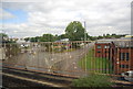
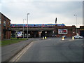
1
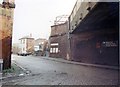
Ardwick station entrance
Dismal entrance, dismal area! Taken from the open space once covered by the link to the Lancashire and Yorkshire Railway at Philips Park.
Image: © Peter Whatley
Taken: 1 Apr 1989
0.04 miles
2
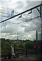
Ardwick railway station entrance, Manchester
Opened in 1842 by the Sheffield, Ashton & Manchester Railway, soon to become part of the Manchester, Sheffield & Lincolnshire Railway, on the line from Manchester Piccadilly to Guide Bridge.
A contender for the least inviting station entrance in the country.
Image: © Nigel Thompson
Taken: 15 Nov 2014
0.04 miles
4
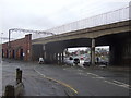
Railway bridge over Devonshire Street North (A665)
Image: © JThomas
Taken: 9 Mar 2013
0.05 miles
5
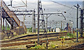
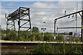
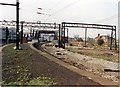
Ardwick station
View eastwards, towards Guide Bridge and Hadfield, formerly to Sheffield Victoria via Woodhead: ex-GCR Manchester - Sheffield main line, electrified 1954 but since 1970 cut back to local services - see other Woodhead Line scenes for details. The photograph was taken from a train out of Manchester Piccadilly on the ex-LNW main line to Stockport, Crewe etc. (electrified in 1960). Unseen to the left was the ex-L&Y loop on viaduct to Philip's Park. There were no platforms at Ardwick on the ex-LNW line, but the footbridge led from the station entrance on Devonshire Street.
Image: © Ben Brooksbank
Taken: 22 Jun 1992
0.05 miles
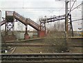
8
Ardwick station
Derelict in 1989, the surrounding area has been substantially regenerated as Manchester's Eastlands.
Image: © Peter Whatley
Taken: 1 Apr 1989
0.06 miles
9
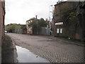
Midland Street /Chancellor Lane junction
Image: © Colin Pyle
Taken: 21 May 2010
0.07 miles