IMAGES TAKEN NEAR TO
Cotter Street, MANCHESTER, M12 6HQ
Introduction
This page details the photographs taken nearby to Cotter Street, M12 6HQ by members of the Geograph project.
The Geograph project started in 2005 with the aim of publishing, organising and preserving representative images for every square kilometre of Great Britain, Ireland and the Isle of Man.

There are currently over 7.5m images from over14,400 individuals and you can help contribute to the project by visiting https://www.geograph.org.uk
Image Map
Images are licensed for reuse under creativecommons.org/licenses/by-sa/2.0
Notes
- Clicking on the map will re-center to the selected point.
- The higher the marker number, the further away the image location is from the centre of the postcode.
Image Listing (250 Images Found)
Images are licensed for reuse under creativecommons.org/licenses/by-sa/2.0
Image
Details
Distance
1
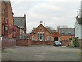
St Thomas's Parish Room
Former Parish Room on Niven Street, now used as offices, viewed from Ardwick Green North across the car park between the Church Inn and the St Thomas Centre.
Image: © Gerald England
Taken: 21 Mar 2012
0.07 miles
2
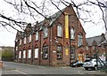
The Old School (St Thomas)
The former St Thomas' School is now the home of "Photoprint" which according to its website [link now defunct] was founded by fashion photographer David Walter in 1977, and has evolved from purely photographic foundations into a multi-disciplinary agency specialising in catalogue design and production, digital and creative print marketing, website design and development, and retail-industry specific creative direction and brand consultancy.
Its main entrance on Thirsk Street is the former "Boys" entrance.
Image: © Gerald England
Taken: 21 Mar 2012
0.07 miles
3
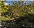
Hoyle Street
Derelict buildings on Hoyle Street in Manchester.
Image: © Peter McDermott
Taken: 15 Oct 2016
0.07 miles
4
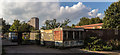
Hoyle Street
Entrance to derelict industrial buildings off Hoyle Street.
Image: © Peter McDermott
Taken: 15 Oct 2016
0.08 miles
5
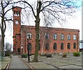
St Thomas Centre, Ardwick Green
The St Thomas Centre was constructed as a 2-storey church in 1741. Over time, the building has been widened and extended eastwards through the formation of a pair of bays. The building has a relatively simple Georgian style of red brick punctuated with 7 vertically aligned windows at ground and first floor levels. The 'Italianate' campanile tower to the west elevation of the building has also been added to the original structure (in 1836). The building incorporates has moulded cornice and a brick parapet concealing a shallow pitched roof.
The building is set back from its southern boundary (with Ardwick Green North) by a graveyard comprising of gravestones that have been laid flat. The southern and western boundaries are defined by brick walls and railings, with a brick wall along the eastern boundary. The northern elevation has a shallow set back from the back of footpath to Niven Street. The southern boundary is punctuated by pedestrian access points to the east and west. The 'western' access has been adapted to provide and accessible route to the main entrance to the building on the western elevation.
The church building was listed as Grade II in 1974 http://www.britishlistedbuildings.co.uk/en-387884-former-church-of-st-thomas-manchester and was declared redundant and deconsecrated as a place of worship in 1978. The building was purchased by Manchester City Council in 1980 and subsequently re-opened as a centre for the voluntary and community use. It functions as an office for Greater Manchester Centre for Voluntary Organisation http://www.gmcvo.org.uk/stc and provides accommodation for other local and national voluntary and community sector groups, providing associated conference, meeting and training events.
Image: © Gerald England
Taken: 21 Mar 2012
0.09 miles
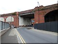
6
Chapelfield Road
Under the viaduct leading to Piccadilly Station. Opposite direction: Image
Image: © Gerald England
Taken: 22 Aug 2009
0.10 miles
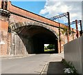
7
Hoyle Street
The railway viaduct in the foreground carried traffic into the former Mayfield railway station. On the left is an entrance to the newly created Mayfield Park.
Image: © Gerald England
Taken: 24 Sep 2022
0.10 miles
8
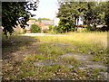
Site of the Church Inn
Site of the now demolished Church Inn Image In the background are former St Thomas's Parish Room Image on Niven Street.
Image: © Gerald England
Taken: 15 Sep 2016
0.10 miles
9
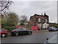
The old Church Inn, Ardwick Green, Manchester
Now shuttered up. Sad. Popular before gigs at the nearby Apollo.
Image: © Jeremy Bolwell
Taken: 29 Nov 2013
0.10 miles
10
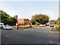
Site of the Church Inn
Site of the Church Inn Image Until something is developed on the site there is now a view of St Thomas's Image
On the corner of Ardwick Green North and Cotter Street is a George V Postbox Image
Image: © Gerald England
Taken: 15 Sep 2016
0.10 miles