IMAGES TAKEN NEAR TO
Palfrey Place, MANCHESTER, M12 6BY

Introduction

This page details the photographs taken nearby to Palfrey Place, M12 6BY by members of the Geograph project.

The Geograph project started in 2005 with the aim of publishing, organising and preserving representative images for every square kilometre of Great Britain, Ireland and the Isle of Man.

There are currently over 7.5m images from over14,400 individuals and you can help contribute to the project by visiting https://www.geograph.org.uk

Image Map


Images are licensed for reuse under creativecommons.org/licenses/by-sa/2.0
Notes
  • Clicking on the map will re-center to the selected point.
  • The higher the marker number, the further away the image location is from the centre of the postcode.

Image Listing (163 Images Found)

Images are licensed for reuse under creativecommons.org/licenses/by-sa/2.0
  • ...
Image
Details
Distance
1
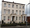
2 & 4 Palfrey Place, Ardwick
A grade II listed https://historicengland.org.uk/listing/the-list/list-entry/1246659?section=official-list-entry pair of Georgian town houses now converted into flats.
Image: © Gerald England Taken: 23 Feb 2013
0.00 miles
2
2 & 4 Palfrey Place, Ardwick
A grade II listed https://historicengland.org.uk/listing/the-list/list-entry/1246659?section=official-list-entry pair of Georgian town houses now converted into flats.
Image: © Gerald England Taken: 20 Feb 2024
0.00 miles
3
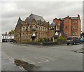
Ardwick Conservative Club (former)
The former Ardwick Conservative Club at 44 Higher Ardwick was built in 1878. Now it occupied by the "Bead Shop" http://web.archive.org/web/20121108030653/http://academy.the-beadshop.co.uk/ which offers a range of jewellery making classes. Image Image Note: Photograph is for record purposes only and the description refers to the situation at the time the photograph was taken. The photographer has no personal connection to any of the businesses depicted.
Image: © Gerald England Taken: 16 Oct 2012
0.02 miles
4
Ardwick Conservative Club: Shield & Date stone
Shield and date stone (1878) on the former Ardwick Conservative Club Image
Image: © Gerald England Taken: 16 Oct 2012
0.02 miles
5
Ardwick Conservative Club: Doorway detail
Detail on the doorway of the former Ardwick Conservative Club Image
Image: © Gerald England Taken: 16 Oct 2012
0.02 miles
6
New Gaelic Club
I believe the building on Higher Ardwick was originally the Primitive Methodist Sunday School.
Image: © Gerald England Taken: 16 Oct 2012
0.02 miles
7
Former Primitive Methodist Sunday School
For some years it was open as the New Gaelic Club.
Image: © Gerald England Taken: 20 Feb 2024
0.02 miles
8
Higher Ardwick
From the corner with Union Street. On the left is the Spicy Grill Image formerly The Union. See how it looked in 1990: http://ackworthborn.blogspot.co.uk/2012/10/higher-ardwick-19902012-from-union-to.html On the right is the former Conservative Club Image
Image: © Gerald England Taken: 16 Oct 2012
0.03 miles
9
Spicy Grill
The tandoori takeaway on the corner of Higher Ardwick and Union Street was formerly the Union Inn. Originally a Wilson's pub, according to the Pubs of Manchester site http://pubs-of-manchester.blogspot.co.uk/2011/07/union-higher-ardwick.html it was a Burtonwood's pub before closing and being converted into the Spicy Grill. See how it looked in 1990: http://ackworthborn.blogspot.co.uk/2012/10/higher-ardwick-19902012-from-union-to.html
Image: © Gerald England Taken: 16 Oct 2012
0.03 miles
10
Spicy Grill
The tandoori takeaway on the corner of Higher Ardwick and Union Street was formerly the Union Inn. Originally a Wilson's pub, according to the Pubs of Manchester site http://pubs-of-manchester.blogspot.co.uk/2011/07/union-higher-ardwick.html it was a Burtonwood's pub before closing and being converted into the Spicy Grill. See how it looked in 1990: http://ackworthborn.blogspot.co.uk/2012/10/higher-ardwick-19902012-from-union-to.html
Image: © Gerald England Taken: 23 Feb 2013
0.03 miles
  • ...