IMAGES TAKEN NEAR TO
Skarratt Street, MANCHESTER, M12 5NF
Introduction
This page details the photographs taken nearby to Skarratt Street, M12 5NF by members of the Geograph project.
The Geograph project started in 2005 with the aim of publishing, organising and preserving representative images for every square kilometre of Great Britain, Ireland and the Isle of Man.

There are currently over 7.5m images from over14,400 individuals and you can help contribute to the project by visiting https://www.geograph.org.uk
Image Map
Images are licensed for reuse under creativecommons.org/licenses/by-sa/2.0
Notes
- Clicking on the map will re-center to the selected point.
- The higher the marker number, the further away the image location is from the centre of the postcode.
Image Listing (88 Images Found)
Images are licensed for reuse under creativecommons.org/licenses/by-sa/2.0
Image
Details
Distance
2
Skarratt Close
Off Wenlock Way, West Gorton.
Image: © Gerald England
Taken: 21 Mar 2012
0.02 miles
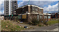
3
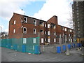
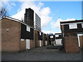
Kelsall Street, West Gorton
Viewed from Gortonvilla Walk. The flats are in the process of being demolished, part of the redevelopment of the Gortonvilla Walk area. Regeneration of West Gorton (from 2010), will be phased over a period of up to 10 years.
Image: © John Topping
Taken: 13 Mar 2013
0.02 miles
4
Brunet Walk
Between Wenlock Way and Clowes Street, West Gorton.
Image: © Gerald England
Taken: 21 Mar 2012
0.03 miles
5
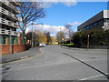
Kniveton Road, West Gorton
At the junction with Wenlock Way.
Image: © John Topping
Taken: 13 Mar 2013
0.05 miles
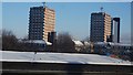
6
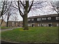
Wenlock Court, West Gorton
On the corner of Wenlock Way and Kniveton Road. Viewed from Skarratt Close.
Image: © John Topping
Taken: 13 Mar 2013
0.05 miles
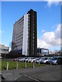
7
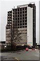
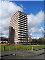
ICL Tower
The old ICL Tower on Wenlock Way in West Gorton, East Manchester.
The building, now being demolished, was designed by architects Cruikshank and Seward in the Sixties, to house the cutting-edge computing power of the time.
Image: © Peter McDermott
Taken: 2 Apr 2018
0.06 miles
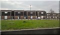
8
Somerwood Walk, West Gorton
Leading to Witterage Close and Wenlock Way, viewed from Gortonvilla Walk. The houses in view are all condemned and waiting to be demolished, part of the redevelopment of the Gortonvilla Walk area. Regeneration of West Gorton (from 2010), will be phased over a period of up to 10 years.
Image: © John Topping
Taken: 13 Mar 2013
0.06 miles