IMAGES TAKEN NEAR TO
Blakedown Walk, MANCHESTER, M12 4RR
Introduction
This page details the photographs taken nearby to Blakedown Walk, M12 4RR by members of the Geograph project.
The Geograph project started in 2005 with the aim of publishing, organising and preserving representative images for every square kilometre of Great Britain, Ireland and the Isle of Man.

There are currently over 7.5m images from over14,400 individuals and you can help contribute to the project by visiting https://www.geograph.org.uk
Image Map
Images are licensed for reuse under creativecommons.org/licenses/by-sa/2.0
Notes
- Clicking on the map will re-center to the selected point.
- The higher the marker number, the further away the image location is from the centre of the postcode.
Image Listing (102 Images Found)
Images are licensed for reuse under creativecommons.org/licenses/by-sa/2.0
Image
Details
Distance
1
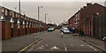
Longsight
South Street in Longsight.
Image: © Peter McDermott
Taken: 15 Feb 2015
0.06 miles
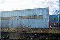
2
Rejuvenated Warehouse, Longsight
On the A6 (Stockport Road) a short distance north of the Plymouth Grove junction.
Image: © Peter Whatley
Taken: 21 Jan 2009
0.07 miles
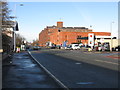
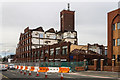
3
Daisy Mill
Image: © Peter McDermott
Taken: 15 Feb 2015
0.09 miles
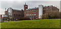
4
Daisy Mill
Demolition of Daisy Mill in Longsight. See also Image
Image: © Peter McDermott
Taken: 10 Apr 2016
0.09 miles
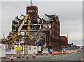
5
Daisy Mill
Demolition of Daisy Mill in Longsight. See also Image
Image: © Peter McDermott
Taken: 10 Apr 2016
0.09 miles