IMAGES TAKEN NEAR TO
Union Street, MANCHESTER, M12 4JD
Introduction
This page details the photographs taken nearby to Union Street, M12 4JD by members of the Geograph project.
The Geograph project started in 2005 with the aim of publishing, organising and preserving representative images for every square kilometre of Great Britain, Ireland and the Isle of Man.

There are currently over 7.5m images from over14,400 individuals and you can help contribute to the project by visiting https://www.geograph.org.uk
Image Map
Images are licensed for reuse under creativecommons.org/licenses/by-sa/2.0
Notes
- Clicking on the map will re-center to the selected point.
- The higher the marker number, the further away the image location is from the centre of the postcode.
Image Listing (202 Images Found)
Images are licensed for reuse under creativecommons.org/licenses/by-sa/2.0
Image
Details
Distance
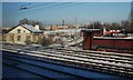
1
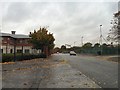
Union Street, Ardwick
From the corner of Brydon Avenue. On the right are the Powerleauge five-a-side football pitches.
Image: © Gerald England
Taken: 16 Oct 2012
0.02 miles
2
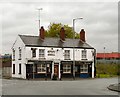
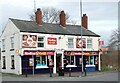
Spicy Grill
The tandoori takeaway on the corner of Higher Ardwick and Union Street was formerly the Union Inn. Originally a Wilson's pub, according to the Pubs of Manchester site http://pubs-of-manchester.blogspot.co.uk/2011/07/union-higher-ardwick.html it was a Burtonwood's pub before closing and being converted into the Spicy Grill.
See how it looked in 1990: http://ackworthborn.blogspot.co.uk/2012/10/higher-ardwick-19902012-from-union-to.html
Image: © Gerald England
Taken: 16 Oct 2012
0.07 miles
3
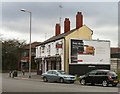
Spicy Grill
The tandoori takeaway on the corner of Higher Ardwick and Union Street was formerly the Union Inn. Originally a Wilson's pub, according to the Pubs of Manchester site http://pubs-of-manchester.blogspot.co.uk/2011/07/union-higher-ardwick.html it was a Burtonwood's pub before closing and being converted into the Spicy Grill.
See how it looked in 1990: http://ackworthborn.blogspot.co.uk/2012/10/higher-ardwick-19902012-from-union-to.html
Image: © Gerald England
Taken: 23 Feb 2013
0.07 miles
4
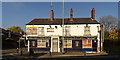
Spicy Grill
The Spicy Grill in Ardwick.
Image: © Peter McDermott
Taken: 1 Nov 2015
0.07 miles
5
Medina Grill
Originally a Wilson's pub called the Union Inn. According to the Pubs of Manchester site http://pubs-of-manchester.blogspot.co.uk/2011/07/union-higher-ardwick.html it was a Burtonwood's pub before closing and being converted into a tandoori takeaway called the Spicy Grill Image
See how it looked in 1990: http://ackworthborn.blogspot.co.uk/2012/10/higher-ardwick-19902012-from-union-to.html
Image: © Gerald England
Taken: 20 Feb 2024
0.07 miles
6
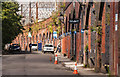
Ardwick
Railway arches on Temperance Street in Ardwick.
Image: © Peter McDermott
Taken: 23 Aug 2014
0.07 miles

8
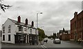
Higher Ardwick
From the corner with Union Street. On the left is the Spicy Grill Image formerly The Union. See how it looked in 1990: http://ackworthborn.blogspot.co.uk/2012/10/higher-ardwick-19902012-from-union-to.html On the right is the former Conservative Club Image
Image: © Gerald England
Taken: 16 Oct 2012
0.08 miles
10
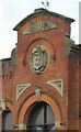
Ardwick Conservative Club: Shield & Date stone
Shield and date stone (1878) on the former Ardwick Conservative Club Image
Image: © Gerald England
Taken: 16 Oct 2012
0.08 miles