IMAGES TAKEN NEAR TO
Eastern-by-Pass, MANCHESTER, M11 4WN
Introduction
This page details the photographs taken nearby to Eastern-by-Pass, M11 4WN by members of the Geograph project.
The Geograph project started in 2005 with the aim of publishing, organising and preserving representative images for every square kilometre of Great Britain, Ireland and the Isle of Man.

There are currently over 7.5m images from over14,400 individuals and you can help contribute to the project by visiting https://www.geograph.org.uk
Image Map
Images are licensed for reuse under creativecommons.org/licenses/by-sa/2.0
Notes
- Clicking on the map will re-center to the selected point.
- The higher the marker number, the further away the image location is from the centre of the postcode.
Image Listing (76 Images Found)
Images are licensed for reuse under creativecommons.org/licenses/by-sa/2.0
Image
Details
Distance
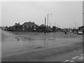
1
Eastern By-Pass!
This road in Clayton is a relic of a road scheme that ended before completion. This section of the Manchester Eastern By-Pass dates, I guess, from the 1930/40's judging by the style of the housing here. It is about 150 metres in length. The only other evidence I have found for this scheme is a similar section in nearby Openshaw Image
Image: © Keith Williamson
Taken: 28 Sep 2005
0.07 miles
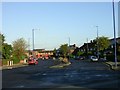
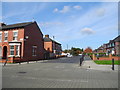
2
Eastern By-Pass, Clayton
Taken on Monday 4th April 2011 from the corner of Stanton Street and Canberra Street
Image: © Mikey
Taken: 4 Apr 2011
0.08 miles
4
Boxing Club, North Road, Clayton - Manchester
The Northside Amateur Boxing Club and Physical Training Centre. Home to Commonwealth Welterweight Champion Crag 'the hammer' Watson.
Image: © John Topping
Taken: 9 Oct 2012
0.11 miles
5
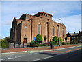
St. Willibord's Catholic Church (2), Clayton - Manchester
Image: © John Topping
Taken: 9 Oct 2012
0.12 miles
6
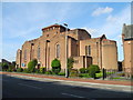
St. Willibord's Catholic Church (1), Clayton - Manchester
On North Road.
Image: © John Topping
Taken: 9 Oct 2012
0.12 miles
7
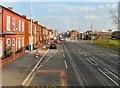
Ashton New Road
The A662 through Clayton. Metrolink tramlines run down the middle of the road. The houses on the left set slightly back from the rest of the terrace were Wallace's florists in 2008 (when the Google streetview car passed by).
Image: © Gerald England
Taken: 1 Mar 2012
0.13 miles
9
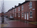
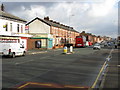
Walsden Street, Clayton, Manchester
An impressively renovated terraced street in the heart of Clayton
Image: © Duncan Watts
Taken: 29 Dec 2011
0.13 miles
10
Vale Street, Clayton - Manchester
At the junction with North Road.
Image: © John Topping
Taken: 9 Oct 2012
0.13 miles