IMAGES TAKEN NEAR TO
Croft Street, MANCHESTER, M11 4RQ
Introduction
This page details the photographs taken nearby to Croft Street, M11 4RQ by members of the Geograph project.
The Geograph project started in 2005 with the aim of publishing, organising and preserving representative images for every square kilometre of Great Britain, Ireland and the Isle of Man.

There are currently over 7.5m images from over14,400 individuals and you can help contribute to the project by visiting https://www.geograph.org.uk
Image Map
Images are licensed for reuse under creativecommons.org/licenses/by-sa/2.0
Notes
- Clicking on the map will re-center to the selected point.
- The higher the marker number, the further away the image location is from the centre of the postcode.
Image Listing (158 Images Found)
Images are licensed for reuse under creativecommons.org/licenses/by-sa/2.0
Image
Details
Distance
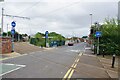
3
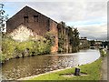
Former Clayton Oil Works
One of a number of chemical related industries in Clayton close to the canal, many now defunct.
Image: © Alan Murray-Rust
Taken: 7 Aug 2013
0.03 miles
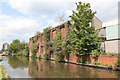
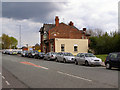
4
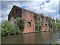
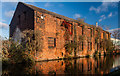
Canalside building off Croft Street
Just above [east of] Lock 8 on the Ashton Canal.
Image: © Christine Johnstone
Taken: 9 May 2014
0.03 miles
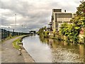
6
Ashton Canal
Buildings alongside the Ashton Canal.
Image: © Peter McDermott
Taken: 30 Nov 2014
0.04 miles
7
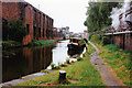
Ashton Canal above lock 8, 1990
The boat is being pushed off to enter the lock.
Image: © Robin Webster
Taken: 18 Sep 1990
0.04 miles
10

Horse chestnuts
A large windfall of horse chestnuts on the pavement of Ashton New Road Image
Image: © Gerald England
Taken: 9 Oct 2013
0.05 miles