IMAGES TAKEN NEAR TO
Linfield Street, MANCHESTER, M11 4RG
Introduction
This page details the photographs taken nearby to Linfield Street, M11 4RG by members of the Geograph project.
The Geograph project started in 2005 with the aim of publishing, organising and preserving representative images for every square kilometre of Great Britain, Ireland and the Isle of Man.

There are currently over 7.5m images from over14,400 individuals and you can help contribute to the project by visiting https://www.geograph.org.uk
Image Map
Images are licensed for reuse under creativecommons.org/licenses/by-sa/2.0
Notes
- Clicking on the map will re-center to the selected point.
- The higher the marker number, the further away the image location is from the centre of the postcode.
Image Listing (170 Images Found)
Images are licensed for reuse under creativecommons.org/licenses/by-sa/2.0
Image
Details
Distance
1
Little Gem
Eponymous car wash on Ashton New Road, Clayton.
Image: © Peter Whatley
Taken: 24 Jan 2009
0.02 miles
2
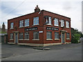
The Victoria
The Victoria a real Manchester working class pub, popular with the Man City faithful when the blues are at home.
Image: © Stephen Burton
Taken: 1 May 2015
0.03 miles
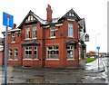
3
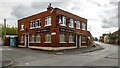
The Victoria
The Victoria public house on Croft Street.
Image: © Peter McDermott
Taken: 2 May 2021
0.03 miles
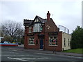
5
Grove Inn
Image: © Gerald England
Taken: 9 Oct 2013
0.04 miles
6
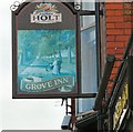
Grove Inn Sign (West face)
Sign for Joseph Holts pub The Grove Inn Image
The sign is the work of Andrew J Holland who tells me "I was working at Donna Hartley Designs and a colleague was looking at the winter side Image I was painting and said the lady looked pregnant so I decided to paint a spring side with the couple pushing a pram."
Image: © Gerald England
Taken: 9 Oct 2013
0.04 miles
7
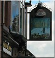
Grove Inn Sign (East face)
Sign for Joseph Holts pub The Grove Inn Image
The sign is the work of Andrew J Holland who tells me "I was working at Donna Hartley Designs and a colleague was looking at the winter side I was painting and said the lady looked pregnant so I decided to paint a spring side Image with the couple pushing a pram."
Image: © Gerald England
Taken: 9 Oct 2013
0.04 miles
8
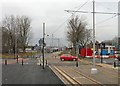
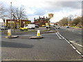
Metrolink crossing Clayton Lane
After Clayton Hall stop the metrolink extension from Droylsden (and eventually Ashton under Lyne) crosses Clayton Lane at a box junction and continues on a dedicated track bed towards the Etihad Stadium (formerly the Commenwealth Games Stadium and later the City of Manchester Stadium), home ground of Manchester City which is visible in the background.
Image: © Gerald England
Taken: 9 Feb 2013
0.05 miles
9
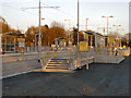
Clayton Hall Tram Station
The new Metrolink stop at Clayton Hall. This is on the south side of Ashton New Road, just to the east of Clayton Lane. It has two side platforms with steps at both ends.
This station is part of the Metrolink East Manchester Line Extension. This line, which will eventually run to Ashton-Under-Lyne, is scheduled to open “before Christmas 2012” between Manchester Piccadilly and Droylsden
http://www.lrta.org/Manchester/ashton.html LRT Association "Metrolink - Manchester to Droylsden and Ashton-Under-Lyne"
http://www.metrolink.co.uk/futuremetrolink/Pages/east-manchester-line.aspx Transport for Greater Manchester - Metrolink East Manchester Line
Image: © David Dixon
Taken: 15 Nov 2012
0.07 miles
10
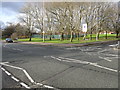
Public Open Space off Clayton Lane, Clayton
Image: © Peter Whatley
Taken: 24 Jan 2009
0.07 miles