IMAGES TAKEN NEAR TO
Stokes Street, MANCHESTER, M11 4QX
Introduction
This page details the photographs taken nearby to Stokes Street, M11 4QX by members of the Geograph project.
The Geograph project started in 2005 with the aim of publishing, organising and preserving representative images for every square kilometre of Great Britain, Ireland and the Isle of Man.

There are currently over 7.5m images from over14,400 individuals and you can help contribute to the project by visiting https://www.geograph.org.uk
Image Map
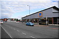
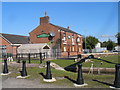
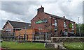
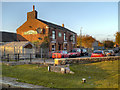
Images are licensed for reuse under creativecommons.org/licenses/by-sa/2.0
Notes
- Clicking on the map will re-center to the selected point.
- The higher the marker number, the further away the image location is from the centre of the postcode.
Image Listing (73 Images Found)
Images are licensed for reuse under creativecommons.org/licenses/by-sa/2.0
Image
Details
Distance
1
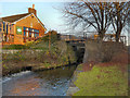
Strawberry Duck public house
This pub stand next to lock 13 of the Ashton Canal. The site of the (now gone) Crabtree Swing Bridge can be seen just beyond the bollards
Image: © John Slater
Taken: 22 Sep 2012
0.05 miles
2
Strawberry Duck pub, Crabtree Lane, Clayton
According to my Nicholson's canal guide 'a traditional two-room pub, over 100 years old'.
Image: © Christine Johnstone
Taken: 9 May 2014
0.05 miles
3
The Strawberry Duck, Crabtree Lane
The Strawberry Duck public house on Crabtree Lane, next to Lock#13 of the Ashton Canal. The two halves of Crabtree Lane used to be linked by a swing bridge across the middle of the lock.
Image: © David Dixon
Taken: 15 Nov 2012
0.06 miles
4
Ashton Canal, Crabtree Lane Lock
Looking east, towards Lock#13 at Crabtree Lane, Clayton, with the Strawberry Duck public house to the left hand side. The two halves of Crabtree Lane used to be linked by a swing bridge across the middle of the lock.
Image: © David Dixon
Taken: 15 Nov 2012
0.06 miles
5
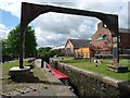
Site of Crabtree Swingbridge at Lock 13, Aston Canal,
The swingbridge across the middle of the lock has been replaced by a footbridge below the bottom gates. Not sure what the function of the 'arch' is - could be an unusual pipe bridge?
Image: © Christine Johnstone
Taken: 9 May 2014
0.07 miles
6
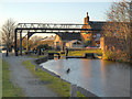
Ashton Canal Lock 13 (Crabtree Lane)
Looking west, towards Lock#13 at Crabtree Lane, Clayton, with the Strawberry Duck public house on the right. The two halves of Crabtree Lane used to be linked by a swing bridge across the middle of the lock.
Image: © David Dixon
Taken: 15 Nov 2012
0.08 miles
7
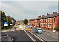
Metrolink Work on Ashton New Road
Viewed from the top deck of a bus between Edge Lane and Clayton.
Image: © Gerald England
Taken: 6 Sep 2010
0.08 miles
8
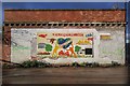
Aim High Dream High
We love our city!
Image: © Peter McDermott
Taken: 2 May 2020
0.09 miles
9
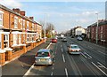
Ashton New Road
The A662 to Droylsden. The terrace on the left is Brightside Terrace, dated 1900. Metrolink tramlines run down the middle of the road and are due to start running in 2012. Viewed from the top deck of a bus.
Image: © Gerald England
Taken: 1 Mar 2012
0.09 miles