IMAGES TAKEN NEAR TO
Ashton New Road, MANCHESTER, M11 4QJ
Introduction
This page details the photographs taken nearby to Ashton New Road, M11 4QJ by members of the Geograph project.
The Geograph project started in 2005 with the aim of publishing, organising and preserving representative images for every square kilometre of Great Britain, Ireland and the Isle of Man.

There are currently over 7.5m images from over14,400 individuals and you can help contribute to the project by visiting https://www.geograph.org.uk
Image Map
Images are licensed for reuse under creativecommons.org/licenses/by-sa/2.0
Notes
- Clicking on the map will re-center to the selected point.
- The higher the marker number, the further away the image location is from the centre of the postcode.
Image Listing (138 Images Found)
Images are licensed for reuse under creativecommons.org/licenses/by-sa/2.0
Image
Details
Distance
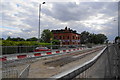
2
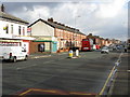
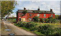
Ashton New Road
The A662 through Clayton. Metrolink tramlines run down the middle of the road. The houses on the left set slightly back from the rest of the terrace were Wallace's florists in 2008 (when the Google streetview car passed by).
Image: © Gerald England
Taken: 1 Mar 2012
0.03 miles
3
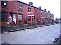
Parrot Street, Clayton, Manchester
Too late for these terraced houses off Ashton New Road - I'm sure they could have been renovated
Image: © Duncan Watts
Taken: 6 Jan 2011
0.05 miles
4
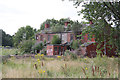
Sick as a Parrot?
These derelict houses- on Parrot Street - are the last remnants of the dense network of terraced streets between Ashton New Road and the Ashton Canal. All the remainder have been demolished, but for some reason these ones are still standing.
Image: © Alan Murray-Rust
Taken: 7 Aug 2013
0.06 miles
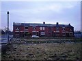
6
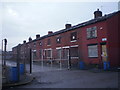
Eswick Street, Clayton, Manchester
One of a number of rows of condemned terraced houses in the former industrial suburb of Clayton, just off Ashton New Road
Image: © Duncan Watts
Taken: 6 Jan 2011
0.06 miles
7
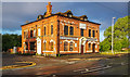
Greens Arms
The Greens Arms was a Wilsons house on the corner of Turner Street and Ashton New Road in Clayton. More recently an Indian restaurant but now closed.
Image: © Peter McDermott
Taken: 2 May 2020
0.06 miles
8
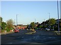
Eastern By-Pass!
This road in Clayton is a relic of a road scheme that ended before completion. This section of the Manchester Eastern By-Pass dates, I guess, from the 1930/40's judging by the style of the housing here. It is about 150 metres in length. The only other evidence I have found for this scheme is a similar section in nearby Openshaw Image
Image: © Keith Williamson
Taken: 28 Sep 2005
0.08 miles
9
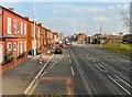
Metrolink works on Ashton New Road
The road is down to one lane controlled by traffic lights, so is currently a place to be avoided. The building beyond has had a succession of owners, usually using the Showbar name but never getting beyond seediness. However as a Chinese restaurant now, it may do better.
Image: © Bill Boaden
Taken: 14 Jun 2010
0.08 miles
10
Eccleshall Street, Clayton, Manchester
A row of condemned houses in Clayton
Image: © Duncan Watts
Taken: 6 Jan 2011
0.08 miles