IMAGES TAKEN NEAR TO
Ralph Street, MANCHESTER, M11 4PF
Introduction
This page details the photographs taken nearby to Ralph Street, M11 4PF by members of the Geograph project.
The Geograph project started in 2005 with the aim of publishing, organising and preserving representative images for every square kilometre of Great Britain, Ireland and the Isle of Man.

There are currently over 7.5m images from over14,400 individuals and you can help contribute to the project by visiting https://www.geograph.org.uk
Image Map
Images are licensed for reuse under creativecommons.org/licenses/by-sa/2.0
Notes
- Clicking on the map will re-center to the selected point.
- The higher the marker number, the further away the image location is from the centre of the postcode.
Image Listing (100 Images Found)
Images are licensed for reuse under creativecommons.org/licenses/by-sa/2.0
Image
Details
Distance
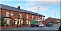
1
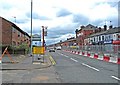
Manchester Road (A662)
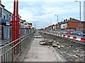
This section of the A662 is called Manchester Road. Elsewhere on its journey through the Manchester area it has other names. The barriers in the road are keeping traffic away from construction work for the Manchester Metrolink, which will be extended along here. Just past the end of the barriers on the right is the Halfway House pub. On the left there is a Tameside "Welcome to Droylsden" sign. This marks both the beginning of Droylsden and the boundary of the Tameside Metropolitan Borough district.
Image: © P L Chadwick
Taken: 2 May 2010
0.02 miles
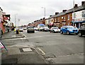
2
Ashton New Road
The A662 from Manchester towards the Tameside boundary. The metrolink tram extension to Droylsden and Ashton is underway. The tramlines here have already been laid. The road looks surprisingly quiet as traffic is waiting at the lights near the Halfway House.
Image: © Gerald England
Taken: 9 Jun 2011
0.02 miles
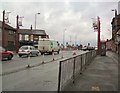
4
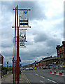
A662 Gateway signs on Manchester Road
These signs are attached to huge dark red painted metal posts, standing on the pavement of Manchester Road, near the Tameside boundary. They were put up by Tameside Metropolitan Borough and mark "The A662 Gateway".
Image: © P L Chadwick
Taken: 2 May 2010
0.03 miles
6
Ashton New Road
The A662 from Droylsden to Clayton and Manchester.
Image: © Gerald England
Taken: 8 Feb 2010
0.04 miles
7
Entering Tameside
The A662 at the Manchester/Tameside border. The roadworks are due to construction work on the Metrolink tramline to Ashton.
Image: © Gerald England
Taken: 8 Feb 2010
0.04 miles
8
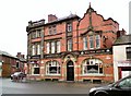
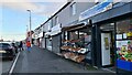
Halfway House
On the A662 halfway between Ashton under Lyne and Manchester.
Image: © Gerald England
Taken: 8 Feb 2010
0.04 miles
9
Manchester Metrolink construction in Manchester Road (A662)
This is preparatory work for the laying of track. The Manchester Metrolink tramway extension to Droylsden will run along here and open in Spring 2012. Later it will be extended to Ashton-under-Lyne.
The tramway will be the third generation of electric street transport to run along here. Manchester's first generation tramway system ran here from the early 20th century until 1938. The road was used by electric trolleybuses from 1938 until December 1966.
Image
Image: © P L Chadwick
Taken: 2 May 2010
0.04 miles
10
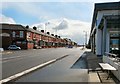
Edge Lane
Looking at houses in Edge Lane from Manchester Road near the Clayton/Droylsden boundary.
Image: © Gerald England
Taken: 17 Jul 2006
0.05 miles