IMAGES TAKEN NEAR TO
Rushbrooke Avenue, MANCHESTER, M11 4JW
Introduction
This page details the photographs taken nearby to Rushbrooke Avenue, M11 4JW by members of the Geograph project.
The Geograph project started in 2005 with the aim of publishing, organising and preserving representative images for every square kilometre of Great Britain, Ireland and the Isle of Man.

There are currently over 7.5m images from over14,400 individuals and you can help contribute to the project by visiting https://www.geograph.org.uk
Image Map
Images are licensed for reuse under creativecommons.org/licenses/by-sa/2.0
Notes
- Clicking on the map will re-center to the selected point.
- The higher the marker number, the further away the image location is from the centre of the postcode.
Image Listing (12 Images Found)
Images are licensed for reuse under creativecommons.org/licenses/by-sa/2.0
Image
Details
Distance
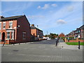
3
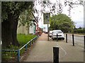
North Road
From the end of Clayton Street.
Image: © Gerald England
Taken: 2 Jun 2014
0.23 miles
4
Vale Street, Clayton - Manchester
At the junction with North Road.
Image: © John Topping
Taken: 9 Oct 2012
0.23 miles
5
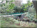
Footbridge over the River Medlock, Clayton Vale
Image: © John Slater
Taken: 29 Sep 2014
0.24 miles
6
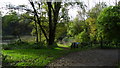
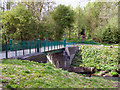
Pond & path jct Clayton Vale, Clayton, Manchester
Image: © Colin Park
Taken: 31 Oct 2019
0.24 miles
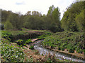
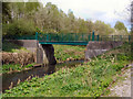
7
Clayton Vale
River Medlock in Clayton Vale.
Image: © Peter McDermott
Taken: 2 Jun 2020
0.24 miles
8
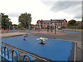
Children's play area at Clayton
Between Clayton Hall and North Road.
Image: © Gerald England
Taken: 12 Sep 2015
0.25 miles
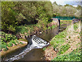
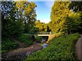
9
Iron Bridge, Clayton Vale
The first of two bridges in Clayton Vale; this one is called "iron Bridge" (for obvious reasons). The other is the brick-built "Clayton Vale Bridge" )Image]).
Image: © David Dixon
Taken: 1 May 2010
0.25 miles