IMAGES TAKEN NEAR TO
Stuart Street, MANCHESTER, M11 4DG
Introduction
This page details the photographs taken nearby to Stuart Street, M11 4DG by members of the Geograph project.
The Geograph project started in 2005 with the aim of publishing, organising and preserving representative images for every square kilometre of Great Britain, Ireland and the Isle of Man.

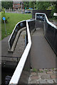
There are currently over 7.5m images from over14,400 individuals and you can help contribute to the project by visiting https://www.geograph.org.uk
Image Map
Images are licensed for reuse under creativecommons.org/licenses/by-sa/2.0
Notes
- Clicking on the map will re-center to the selected point.
- The higher the marker number, the further away the image location is from the centre of the postcode.
Image Listing (144 Images Found)
Images are licensed for reuse under creativecommons.org/licenses/by-sa/2.0
Image
Details
Distance
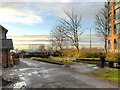
1
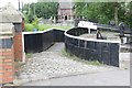
Ashton Canal, Lock 7
Lock 7 was named Park Lock after the nearby Philips Park, the world's first Municipal Park.
Image: © David Dixon
Taken: 21 Nov 2012
0.01 miles
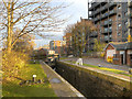
2
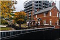
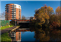
Park Lock, Ashton Canal
Park Lock, next to Alan Turing Way.
In the background is one of the two giant gasholders built for the Bradford Gasworks in the second half of the nineteenth century. One of the last reminders that up until the late 1960s, This was a heavily industrialised area. The gasworks, together with Bradford Colliery and Bradford Ironworks (Richard Johnson and Nephew) dominated a heavily industrialised landscape of which little remains apart from the two gasholders. The Eastlands regeneration area is now home to one of the Europe's biggest concentrations of sporting venues, as well as acres of green space, shops and leisure facilities and a range of canalside residential developments such as the one on the right hand side of the picture.
Image: © David Dixon
Taken: 21 Nov 2012
0.02 miles
3
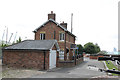
Lock keeper's cottage
Not built at the same time as the canal - it has the date 1865 under the porch http://www.geograph.org.uk/photo/3592981 . Located alongside Lock No.7 - Park or Beswick Lock - and Listed Grade II.
Image: © Alan Murray-Rust
Taken: 7 Aug 2013
0.02 miles
4
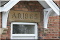
Date stone on the lock keeper's cottage
An unusually impressive feature for a small dwelling http://www.geograph.org.uk/photo/3592977 .
Image: © Alan Murray-Rust
Taken: 7 Aug 2013
0.02 miles
5
Roving bridge at Lock No.7 (2)
See http://www.geograph.org.uk/photo/3592986 for details. The bottom end of the ramp is particularly steep and particular care would need to have been taken with the horse to avoid it slipping and potentially falling into the canal.
Image: © Alan Murray-Rust
Taken: 7 Aug 2013
0.02 miles
6
Ashton Canal
Lock-keepers Cottage on the Ashton Canal.
Image: © Peter McDermott
Taken: 17 Oct 2014
0.03 miles
7
Roving bridge at Lock No.7 (1)
See also http://www.geograph.org.uk/photo/3592988 . An unusual version of a roving bridge, designed to carry the towpath from one side of the canal to the other. Normally they form a spiral enabling the move to be made without unhitching the horse, but in this case it would have been necessary. However, the location immediately adjacent to a lock would have meant that it was not so critical here. The metal sheeting was clearly intended to ensure smooth passage of the tow rope - note the grooves worn into the iron uprights. The lock and bridge are Listed Grade II.
Image: © Alan Murray-Rust
Taken: 7 Aug 2013
0.03 miles
8
Houses in Stuart Street
On the north side of the Ashton Canal.
Image: © Christine Johnstone
Taken: 9 May 2014
0.03 miles
9
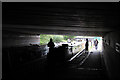
Ashton Canal
The Ashton Canal passing under Alan Turing Way.
Image: © Peter McDermott
Taken: 30 Nov 2014
0.03 miles
10
Traffic jam under Alan Turing Way
The two boats were going in opposite directions. The one on the right is waiting while the one in front negotiates Lock No.6.
Image: © Alan Murray-Rust
Taken: 7 Aug 2013
0.04 miles