IMAGES TAKEN NEAR TO
The Waterfront, MANCHESTER, M11 4AF
Introduction
This page details the photographs taken nearby to The Waterfront, M11 4AF by members of the Geograph project.
The Geograph project started in 2005 with the aim of publishing, organising and preserving representative images for every square kilometre of Great Britain, Ireland and the Isle of Man.

There are currently over 7.5m images from over14,400 individuals and you can help contribute to the project by visiting https://www.geograph.org.uk
Image Map
Images are licensed for reuse under creativecommons.org/licenses/by-sa/2.0
Notes
- Clicking on the map will re-center to the selected point.
- The higher the marker number, the further away the image location is from the centre of the postcode.
Image Listing (172 Images Found)
Images are licensed for reuse under creativecommons.org/licenses/by-sa/2.0
Image
Details
Distance
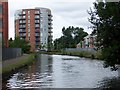
1
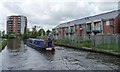
Narrowboat heading west, Ashton Canal
Approaching Lock 7, above Forge Lane Bridge.
Image: © Christine Johnstone
Taken: 9 May 2014
0.01 miles
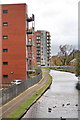
2
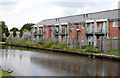
Canalside housing
What a shame that the high fences discourage the trimming of excess vegetation.
Image: © Alan Murray-Rust
Taken: 7 Aug 2013
0.02 miles
4
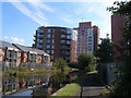
Circular apartment block
It must be a nightmare finding furniture to fit the awkward spaces resulting!
Image: © Alan Murray-Rust
Taken: 7 Aug 2013
0.03 miles
5
Ashton Canal
Taken from the bridge by the Velodrome
Image: © Bob Jenkins
Taken: 1 Nov 2009
0.03 miles
6
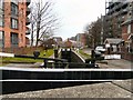
Ashton Canal
Lock #7 on the Ashton Canal from Alan Turing Way.
Image: © Gerald England
Taken: 23 Mar 2010
0.05 miles
7
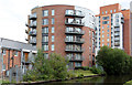
Cylindrical apartment block beside Ashton Canal
Image: © David Martin
Taken: 2 Aug 2010
0.05 miles
8
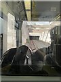
Approaching tunnel under Alan Turing Way
View from behind the tram driver approaching the tunnel under Alan Turing Way, Manchester
Image: © Paul Foster
Taken: 23 Sep 2023
0.06 miles
9
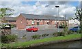
Houses in Stuart Street
On the north side of the Ashton Canal.
Image: © Christine Johnstone
Taken: 9 May 2014
0.07 miles
10
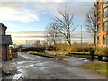
Park Lock, Ashton Canal
Park Lock, next to Alan Turing Way.
In the background is one of the two giant gasholders built for the Bradford Gasworks in the second half of the nineteenth century. One of the last reminders that up until the late 1960s, This was a heavily industrialised area. The gasworks, together with Bradford Colliery and Bradford Ironworks (Richard Johnson and Nephew) dominated a heavily industrialised landscape of which little remains apart from the two gasholders. The Eastlands regeneration area is now home to one of the Europe's biggest concentrations of sporting venues, as well as acres of green space, shops and leisure facilities and a range of canalside residential developments such as the one on the right hand side of the picture.
Image: © David Dixon
Taken: 21 Nov 2012
0.07 miles