IMAGES TAKEN NEAR TO
Ashton Old Road, MANCHESTER, M11 3WU
Introduction
This page details the photographs taken nearby to Ashton Old Road, M11 3WU by members of the Geograph project.
The Geograph project started in 2005 with the aim of publishing, organising and preserving representative images for every square kilometre of Great Britain, Ireland and the Isle of Man.

There are currently over 7.5m images from over14,400 individuals and you can help contribute to the project by visiting https://www.geograph.org.uk
Image Map
Images are licensed for reuse under creativecommons.org/licenses/by-sa/2.0
Notes
- Clicking on the map will re-center to the selected point.
- The higher the marker number, the further away the image location is from the centre of the postcode.
Image Listing (37 Images Found)
Images are licensed for reuse under creativecommons.org/licenses/by-sa/2.0
Image
Details
Distance
1
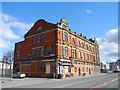
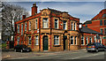
Ex, Co-op Building, Beswick
Formerly Beswick Co-op Society building, on the corner of Ashton Old Road (A635) and Claribel Street.
Image: © John Topping
Taken: 13 Mar 2013
0.00 miles
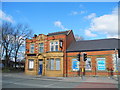
2
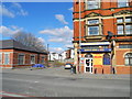
Beswick Booze & News
On the corner of Ashton Old Road (A635) and Claribel Street.
Image: © John Topping
Taken: 13 Mar 2013
0.01 miles
3
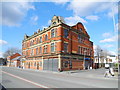
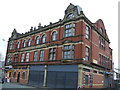
Ex, Co-op Building, Beswick
Formerly Beswick Co-op Society building, on the corner of Ashton Old Road (A635) and Bellew Street.
Image: © John Topping
Taken: 13 Mar 2013
0.01 miles
4
Former Beswick Co Operative Society Building
Image: © JThomas
Taken: 18 May 2013
0.01 miles
5
Seven Stars
The Seven Stars public house.
Image: © Peter McDermott
Taken: 26 Apr 2014
0.02 miles
6
Seven Stars, Beswick
Formerly a Joseph Holt brewery public house on Ashton Old Road. Now closed and boarded up.
Image: © John Topping
Taken: 13 Mar 2013
0.02 miles
7
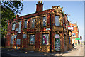
The Seven Stars - a Holts pub which didn't make it
Holts pubs seem to be more resilient than most, probably due to the no-nonsense, generally consistent beer at more reasonable prices. This one didn't survive.
Image: © Bill Boaden
Taken: 22 Jun 2010
0.03 miles
8
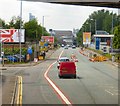
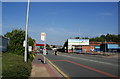
Ashton Old Road
The A635 about a mile from the City Centre passing under a bridge that carries a loop line that connects Ashburys with railway lines that go in and out of Victoria.
Image: © Gerald England
Taken: 13 Jun 2015
0.05 miles
9
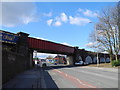
Railway Bridge, Ashton Old Road/Ardwick
Bridge PPA2/4 (above Ashton Old Road), carries the Ashburys to Philips Park line.
Image: © John Topping
Taken: 13 Mar 2013
0.05 miles
10
Ashton Old Road, Ardwick
The far railway bridge is still active while another spur ends abruptly behind the hoarding. Both lines linked the ones issuing from Piccadilly and Victoria Stations, presumably for goods traffic.
Image: © Bill Boaden
Taken: 22 Jun 2010
0.10 miles