IMAGES TAKEN NEAR TO
Mountfield Walk, MANCHESTER, M11 3UG
Introduction
This page details the photographs taken nearby to Mountfield Walk, M11 3UG by members of the Geograph project.
The Geograph project started in 2005 with the aim of publishing, organising and preserving representative images for every square kilometre of Great Britain, Ireland and the Isle of Man.

There are currently over 7.5m images from over14,400 individuals and you can help contribute to the project by visiting https://www.geograph.org.uk
Image Map
Images are licensed for reuse under creativecommons.org/licenses/by-sa/2.0
Notes
- Clicking on the map will re-center to the selected point.
- The higher the marker number, the further away the image location is from the centre of the postcode.
Image Listing (123 Images Found)
Images are licensed for reuse under creativecommons.org/licenses/by-sa/2.0
Image
Details
Distance
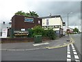
3
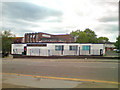
Mary D's Beamish Bar (former Labour Club), 13 Grey Mare Lane
This huge pub used to be a Labour Party club, but for at least 16 years it has been a pub. It can accommodate around 1,200 people and has two machines which are each capable of pouring six pints in 20 seconds. So there is no doubt that some serious drinking goes on here. The busiest days are when Manchester City Football Club is playing at home. It is one of the many pubs around here popular with City fans. At other times it can be quiet, and in 2009 the owner announced he was considering applying for planning permission to demolish the building and replace it with a new hotel and bar complex.
The pub is on the corner of Grey Mare Lane and Howarth Close. It extends a long way back along the latter. The owner's mother-in-law owns a Mary D's bar in Puerto Rico, Gran Canaria, which is popular with holidaying City fans.
At the moment this area is very far from being a tourist destination for visitors to Manchester. The litter on the pavement, the extra protection on the pub's downstairs windows, and the CCT camera on the corner of the building, encased in a metal grill, tell their own story.
Image: © P L Chadwick
Taken: 2 May 2010
0.08 miles
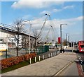
4
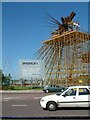
B of the Bang under construction
At Sportcity which is home to the City of Manchester Stadium, Regional Athletics Arena, National Squash Centre, English Institute of Sport Tennis Centre and the National Cycling Centre.
Image: © Gerald England
Taken: 7 Sep 2004
0.11 miles
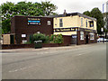
5
The Eastlands Bar, Manchester
Draped in Manchester City colours, yet they feel the need to have a sign outside saying "Home Fans Only".....
Image: © Stephen Sweeney
Taken: 21 Jun 2011
0.11 miles
6
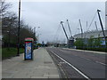
Sportcity
The City of Manchester stadium alongside Ashton New Road (viewed from the top deck of a bus). Originally built for the Commonwealth Games it became the home ground of Manchester City and has recently been renamed as the Ethiad Stadium.
Image: © Gerald England
Taken: 1 Mar 2012
0.11 miles
7
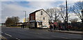
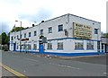
Maine Road Chippy
This building is the sole survivor of a terrace that fronted Ashton New Road. It is shown on the 1893 OS 1/2500 map.
Image: © Paul Collins
Taken: 8 Jan 2023
0.11 miles
10
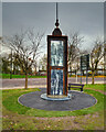
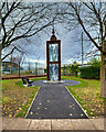
Memorial at the former Bradford Colliery Site
Image: © David Dixon
Taken: 23 Nov 2020
0.13 miles