IMAGES TAKEN NEAR TO
Philips Park Road, MANCHESTER, M11 3FU
Introduction
This page details the photographs taken nearby to Philips Park Road, M11 3FU by members of the Geograph project.
The Geograph project started in 2005 with the aim of publishing, organising and preserving representative images for every square kilometre of Great Britain, Ireland and the Isle of Man.

There are currently over 7.5m images from over14,400 individuals and you can help contribute to the project by visiting https://www.geograph.org.uk
Image Map
Images are licensed for reuse under creativecommons.org/licenses/by-sa/2.0
Notes
- Clicking on the map will re-center to the selected point.
- The higher the marker number, the further away the image location is from the centre of the postcode.
Image Listing (154 Images Found)
Images are licensed for reuse under creativecommons.org/licenses/by-sa/2.0
Image
Details
Distance
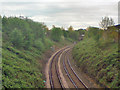
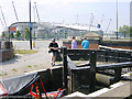
1

Ashton Canal near the City of Manchester Stadium
Image: © Chris Wimbush
Taken: 31 Jan 2009
0.05 miles
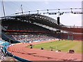
2
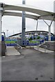
Etihad & Athletics Arena
Looking across the athletics track towards Man' City's footie stadium.
Image: © Glyn Baker
Taken: 11 Sep 2021
0.07 miles
3
City of Manchester Stadium from the Canal
Image: © Nigel Homer
Taken: 29 Jul 2002
0.07 miles
4
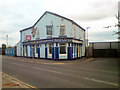
Maine Road
Public house on Rowsley Street, outside the City of Manchester Stadium, named after Manchester City's old football ground.
Image: © David Dixon
Taken: 19 May 2010
0.09 miles
5
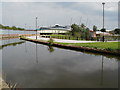
Metrolink East Manchester Extension
The new East Manchester line crossing the River Medlock, just north of Cambrian Street Bridge.
Image: © David Dixon
Taken: 14 Nov 2012
0.09 miles
7
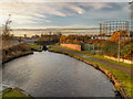
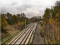
Ashton Canal, Bradford
Looking to the west, from Lock 5.
To the right hand side is one of the two giant gasholders built for the Bradford Gasworks in the second half of the nineteenth century. Up until the late 1960s, the gasworks together with Bradford Colliery and Bradford Ironworks (Richard Johnson and Nephew) dominated a heavily industrialised landscape which little remains apart from the two gasholders. The Eastlands regeneration area is now home to one of the Europe's biggest concentrations of sporting venues, as well as acres of green space, shops and leisure facilities and a range of canalside residential developments.
Image: © David Dixon
Taken: 21 Nov 2012
0.10 miles
8
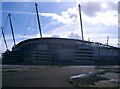
City of Manchester Stadium
New Manchester City ground.
Image: © Gary Barber
Taken: 7 Apr 2005
0.10 miles
9
City of Manchester Stadium from Ashton Canal
The City of Manchester Stadium, built for the Commonwealth Games, seen from Lock 7 of the Ashton Canal.
Image: © Martin Clark
Taken: Unknown
0.10 miles
10
City of Manchester Stadium - Commonwealth Games
Photo of the City of Manchester Stadium taken at the Commonwealth Games of 2002. The stadium was later converted into a football stadium.
Image: © Tony Smith
Taken: Unknown
0.10 miles