IMAGES TAKEN NEAR TO
Alan Turing Way, MANCHESTER, M11 3BS
Introduction
This page details the photographs taken nearby to Alan Turing Way, M11 3BS by members of the Geograph project.
The Geograph project started in 2005 with the aim of publishing, organising and preserving representative images for every square kilometre of Great Britain, Ireland and the Isle of Man.

There are currently over 7.5m images from over14,400 individuals and you can help contribute to the project by visiting https://www.geograph.org.uk
Image Map
Images are licensed for reuse under creativecommons.org/licenses/by-sa/2.0
Notes
- Clicking on the map will re-center to the selected point.
- The higher the marker number, the further away the image location is from the centre of the postcode.
Image Listing (19 Images Found)
Images are licensed for reuse under creativecommons.org/licenses/by-sa/2.0
Image
Details
Distance
1
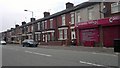
Mill Street, Manchester
Social housing on Mill Street at the conjunction of the Beswick/Bradford/Openshaw areas of northeastern Manchester, in Greater Manchester, England.
Image: © Steven Haslington
Taken: 27 Jun 2011
0.08 miles
2
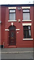
55 Selby Street, Openshaw
55 Selby Street, a red-brick terraced house in the Openshaw area of Manchester, England. Such houses are typical of Greater Manchester.
Image: © Steven Haslington
Taken: 27 Jun 2011
0.10 miles
5
Clayton Lane, Openshaw
Terraced properties on Clayton Lane, in the Openshaw area of Manchester, Greater Manchester, England.
Image: © Steven Haslington
Taken: 27 Jun 2011
0.17 miles
6
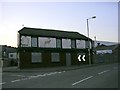
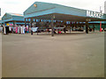
Last Orders!
The Fox Tavern, Clayton Lane, Openshaw. Closed 2003. Situated in a rather neglected area of east Manchester that is now undergoing regeneration on a big scale.
Image: © Keith Williamson
Taken: 2 Sep 2005
0.17 miles
8
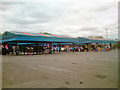
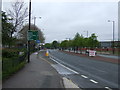
Parkhouse Street
Leading out of West Openshaw into Lower Openshaw and onto Clayton Lane.
Image: © Gerald England
Taken: 28 Sep 2016
0.19 miles
9
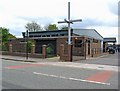
St. Brigid's Catholic Church, Grey Mare Lane, Bradford, Manchester
This modern church replaced a large Victorian church of the same name in Mill Street. This area of Manchester is sometimes called Bradford - not to be confused with the large City of the same name in West Yorkshire.
Image: © P L Chadwick
Taken: 2 May 2010
0.21 miles
10
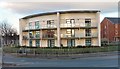
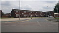
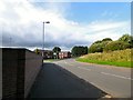
Turing Close
New housing in East Manchester at the corner of Ashton Old Road and Alan Turing Way.
Image: © Gerald England
Taken: 28 Nov 2012
0.21 miles