IMAGES TAKEN NEAR TO
Howarth Close, MANCHESTER, M11 3BR
Introduction
This page details the photographs taken nearby to Howarth Close, M11 3BR by members of the Geograph project.
The Geograph project started in 2005 with the aim of publishing, organising and preserving representative images for every square kilometre of Great Britain, Ireland and the Isle of Man.

There are currently over 7.5m images from over14,400 individuals and you can help contribute to the project by visiting https://www.geograph.org.uk
Image Map
Images are licensed for reuse under creativecommons.org/licenses/by-sa/2.0
Notes
- Clicking on the map will re-center to the selected point.
- The higher the marker number, the further away the image location is from the centre of the postcode.
Image Listing (116 Images Found)
Images are licensed for reuse under creativecommons.org/licenses/by-sa/2.0
Image
Details
Distance
1

Mary D's Beamish Bar (former Labour Club), 13 Grey Mare Lane
This huge pub used to be a Labour Party club, but for at least 16 years it has been a pub. It can accommodate around 1,200 people and has two machines which are each capable of pouring six pints in 20 seconds. So there is no doubt that some serious drinking goes on here. The busiest days are when Manchester City Football Club is playing at home. It is one of the many pubs around here popular with City fans. At other times it can be quiet, and in 2009 the owner announced he was considering applying for planning permission to demolish the building and replace it with a new hotel and bar complex.
The pub is on the corner of Grey Mare Lane and Howarth Close. It extends a long way back along the latter. The owner's mother-in-law owns a Mary D's bar in Puerto Rico, Gran Canaria, which is popular with holidaying City fans.
At the moment this area is very far from being a tourist destination for visitors to Manchester. The litter on the pavement, the extra protection on the pub's downstairs windows, and the CCT camera on the corner of the building, encased in a metal grill, tell their own story.
Image: © P L Chadwick
Taken: 2 May 2010
0.03 miles

3

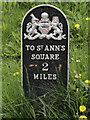
Old Milepost by the A662, Ashton New Road, Beswick
Cast iron post by the A662, in parish of MANCHESTER (MANCHESTER District), Ashton New Road; Beswick, junction with the A6010 on embankment, on South side of road. St Anne's post, erected by the District Council in the 19th century.
Inscription reads:-
{coat of arms}
TO ST. ANN'S
SQUARE
2
MILES
Milestone Society National ID: LA_MAAL02
Image: © M Faherty
Taken: 16 Jul 2007
0.06 miles
4
Old Milepost by the A662, Ashton New Road, Beswick
Cast iron post by the A662, in parish of MANCHESTER (MANCHESTER District), Ashton New Road; Beswick, junction with the A6010 on embankment, on South side of road. St Anne's post, erected by the District Council in the 19th century.
Inscription reads:-
{coat of arms}
TO ST. ANN'S
SQUARE
2
MILES
Milestone Society National ID: LA_MAAL02
Image: © Roadside Relics
Taken: 9 May 2018
0.06 miles
5
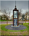
Memorial at the former Bradford Colliery Site
Image: © David Dixon
Taken: 23 Nov 2020
0.06 miles
6

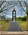
Bradford Colliery 1590-1973
This glass and steel memorial is a remembrance of all those who worked in the Bradford pit for a few years shy of 400 years.
Image: © Glyn Baker
Taken: 11 Sep 2021
0.06 miles
8

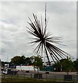
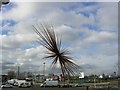
B of the Bang
The sign adjacent to the sculpture Image describes it as "New Landmark Public Art for the North West designed by Thomas Heatherwick Studio".
Image: © Gerald England
Taken: 20 Feb 2009
0.07 miles
9
End of the Bang
The "B of the Bang" in the process of being dismantled.
Image: © Gerald England
Taken: 18 May 2009
0.08 miles
10
The B of the Bang!
At the corner of Ashton New Road and Alan Turing Way, close to the City of Manchester Stadium.
Image: © Keith Williamson
Taken: 21 Feb 2005
0.08 miles