IMAGES TAKEN NEAR TO
Chassen Close, MANCHESTER, M11 3BQ
Introduction
This page details the photographs taken nearby to Chassen Close, M11 3BQ by members of the Geograph project.
The Geograph project started in 2005 with the aim of publishing, organising and preserving representative images for every square kilometre of Great Britain, Ireland and the Isle of Man.

There are currently over 7.5m images from over14,400 individuals and you can help contribute to the project by visiting https://www.geograph.org.uk
Image Map
Images are licensed for reuse under creativecommons.org/licenses/by-sa/2.0
Notes
- Clicking on the map will re-center to the selected point.
- The higher the marker number, the further away the image location is from the centre of the postcode.
Image Listing (37 Images Found)
Images are licensed for reuse under creativecommons.org/licenses/by-sa/2.0
Image
Details
Distance
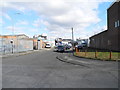
1
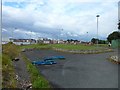
Waste ground, Beswick, Manchester
Scene of much recent redevelopment however.
Image: © Stephen Sweeney
Taken: 21 Jun 2011
0.02 miles
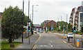
2
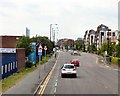
Ashton Old Road, Beswick
The A635 into Manchester.
Image: © Gerald England
Taken: 13 Jun 2015
0.11 miles
3
Ashton Old Road, Ashburys
The A635 a mile and a half Image from Manchester City Centre.
Image: © Gerald England
Taken: 13 Jun 2015
0.12 miles
4
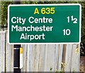
Sign on the A635
The sign at Ashburys Image reads One and half miles to the City Centre and 10 miles to Manchester Airport.
Image: © Gerald England
Taken: 13 Jun 2015
0.13 miles
5
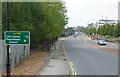
Ashton Old Road
The A635 into Manchester. The road here has been widened in recent years after housing on the north side of the road was cleared and new housing built a little further back from the road.
Image: © Gerald England
Taken: 13 Jun 2015
0.17 miles
6

Ashton Old Road, Manchester
Strangely not marked as dual carriageway on the OS map. Leering over the city on the horizon is the 551ft-high Beetham Tower, which at the time of this image being taken is the tallest building in the UK outside of London.
Image: © Stephen Sweeney
Taken: 21 Jun 2011
0.19 miles
7
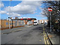
Stainforth Street
Wing Fat chinese cash & carry on the left.
Image: © John Topping
Taken: 13 Mar 2013
0.20 miles
9
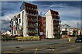
Ashton Old Road
New flats on Ashton Old Road.
Image: © Peter McDermott
Taken: 26 Apr 2014
0.20 miles
10
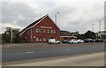
Cornerstone Centre
The family practitioner service on Graham Street across Ashton Old Road was formerly Mill Street Medical Centre http://www.cornerstonefamilypractice.nhs.uk/
Image: © Gerald England
Taken: 6 Aug 2018
0.20 miles