IMAGES TAKEN NEAR TO
Claybrook Walk, MANCHESTER, M11 3BL
Introduction
This page details the photographs taken nearby to Claybrook Walk, M11 3BL by members of the Geograph project.
The Geograph project started in 2005 with the aim of publishing, organising and preserving representative images for every square kilometre of Great Britain, Ireland and the Isle of Man.

There are currently over 7.5m images from over14,400 individuals and you can help contribute to the project by visiting https://www.geograph.org.uk
Image Map
Images are licensed for reuse under creativecommons.org/licenses/by-sa/2.0
Notes
- Clicking on the map will re-center to the selected point.
- The higher the marker number, the further away the image location is from the centre of the postcode.
Image Listing (91 Images Found)
Images are licensed for reuse under creativecommons.org/licenses/by-sa/2.0
Image
Details
Distance
1
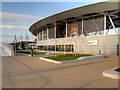
Manchester City Training Academy, Etihad Campus
Image: © David Dixon
Taken: 7 Mar 2015
0.04 miles
2
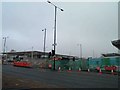
Alan Turing Way, Manchester
On the right is the new Academy for Manchester City FC under construction.
Image: © Steve Fareham
Taken: 17 Nov 2013
0.05 miles

4
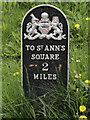
Old Milepost by the A662, Ashton New Road, Beswick
Cast iron post by the A662, in parish of MANCHESTER (MANCHESTER District), Ashton New Road; Beswick, junction with the A6010 on embankment, on South side of road. St Anne's post, erected by the District Council in the 19th century.
Inscription reads:-
{coat of arms}
TO ST. ANN'S
SQUARE
2
MILES
Milestone Society National ID: LA_MAAL02
Image: © Roadside Relics
Taken: 9 May 2018
0.06 miles
5

Old Milepost by the A662, Ashton New Road, Beswick
Cast iron post by the A662, in parish of MANCHESTER (MANCHESTER District), Ashton New Road; Beswick, junction with the A6010 on embankment, on South side of road. St Anne's post, erected by the District Council in the 19th century.
Inscription reads:-
{coat of arms}
TO ST. ANN'S
SQUARE
2
MILES
Milestone Society National ID: LA_MAAL02
Image: © M Faherty
Taken: 16 Jul 2007
0.06 miles
6
Footpath for football fans
A new footbridge has been erected across the busy junction of Ashton New Road and Alan Turing Way linking the Ethiad Stadium with the new Football Academy.
Image: © Gerald England
Taken: 2 Jun 2014
0.07 miles
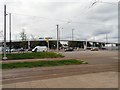
7
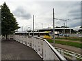
Junction of Ashton New Road and Alan Turing Way
The busy junction of Ashton New Road (A635) and Alan Turing Way (A6010) viewed from the steps of the Asda superstore. In the foreground is a Metrolink Tram en route from Ashton under Lyne to Eccles. In the background is a new footbridge linking the Etihad Stadium with the new Football Academy.
Image: © Gerald England
Taken: 2 Jun 2014
0.07 miles
8
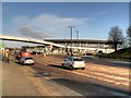
Ashton New Road, Footbridge and Academy Stadium
Looking eastwards along Ashton New Road (A662) towards its junction with Alan Turing Way (A6010). The footbridge over the junction connects the main part of the Etihad Campus (including the Etihad Stadium), on the left, with the new Manchester City Academy Arena which can be seen just beyond the bridge.
Image: © David Dixon
Taken: 7 Mar 2015
0.07 miles
9
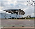
Stand at the Football Training Academy
The new sports academy not far from Manchester City's Ethiad Stadium is built on what was formerly mainly industrial land. The GR postbox Image was originally outside the Bradford Old Post Office. Only the box survives.
Image: © Gerald England
Taken: 30 Dec 2014
0.07 miles
10
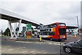
Junction on Alan Turing Way
The flyover is a footway linking the football academy and the main stadium nearby.
Image: © Glyn Baker
Taken: 11 Sep 2021
0.07 miles