IMAGES TAKEN NEAR TO
Victoria Street, MANCHESTER, M11 2LU
Introduction
This page details the photographs taken nearby to Victoria Street, M11 2LU by members of the Geograph project.
The Geograph project started in 2005 with the aim of publishing, organising and preserving representative images for every square kilometre of Great Britain, Ireland and the Isle of Man.

There are currently over 7.5m images from over14,400 individuals and you can help contribute to the project by visiting https://www.geograph.org.uk
Image Map
Images are licensed for reuse under creativecommons.org/licenses/by-sa/2.0
Notes
- Clicking on the map will re-center to the selected point.
- The higher the marker number, the further away the image location is from the centre of the postcode.
Image Listing (29 Images Found)
Images are licensed for reuse under creativecommons.org/licenses/by-sa/2.0
Image
Details
Distance
1
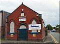
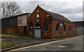
Beulah Hall
Previously the Welsh Methodist Chapel.
Image: © Gerald England
Taken: 14 Sep 2009
0.07 miles
2
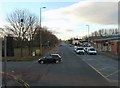
Ashton Old Road
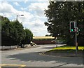
The A635 from Ashton under Lyne to Manchester via Openshaw near the entrance to the New Smithfield Market which is on the left. Market traffic from Manchester has to turn left after Compass Street on to South Street Image in order to then cross Ashton Old Road at these traffic lights. This avoids queues on the A635 where there is now no right turn, hence the box junction markings on the right.
Image: © Gerald England
Taken: 28 Nov 2012
0.07 miles
3
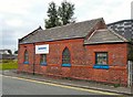
Beulah Hall
Previously the Welsh Methodist Chapel.
Image: © Gerald England
Taken: 14 Sep 2009
0.07 miles
4
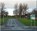
Turn left to go right
Traffic for New Smithfield Market is signed to turn left here off Ashton Old Road so it can take two right turns on to South Street and Westlake Street in order to cross Ashton Old Road Image at the traffic lights where there is no right turn.
Image: © Gerald England
Taken: 28 Nov 2012
0.09 miles
5
New Smithfield Market
The entrance off Ashton Old Road leading to the New Smithfield Market formerly Gorton Wholesale Market.
Image: © Gerald England
Taken: 22 Aug 2009
0.09 miles
6
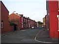
Hovis Street, Openshaw
A typical side street in this part of east Manchester. SJ883976.
Image: © Keith Williamson
Taken: 2 Sep 2005
0.09 miles
7
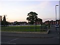
Openshaw Park
Previously known as George Street Recreation Ground. SJ883976.
Image: © Keith Williamson
Taken: 2 Sep 2005
0.09 miles
8
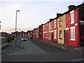
Elysian Street, Openshaw
Situated next to Openshaw Park. SJ883976.
Image: © Keith Williamson
Taken: 2 Sep 2005
0.09 miles
9
Old Chapel
Old Welsh Methodist Chapel.
Image: © Peter McDermott
Taken: 2 Jan 2020
0.10 miles
10
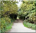
Footpath to Clayton
Along the route of the filled-in Stockport Branch Canal.
Image: © Gerald England
Taken: 14 Sep 2009
0.11 miles