IMAGES TAKEN NEAR TO
Edzell Walk, MANCHESTER, M11 2GD
Introduction
This page details the photographs taken nearby to Edzell Walk, M11 2GD by members of the Geograph project.
The Geograph project started in 2005 with the aim of publishing, organising and preserving representative images for every square kilometre of Great Britain, Ireland and the Isle of Man.

There are currently over 7.5m images from over14,400 individuals and you can help contribute to the project by visiting https://www.geograph.org.uk
Image Map
Images are licensed for reuse under creativecommons.org/licenses/by-sa/2.0
Notes
- Clicking on the map will re-center to the selected point.
- The higher the marker number, the further away the image location is from the centre of the postcode.
Image Listing (62 Images Found)
Images are licensed for reuse under creativecommons.org/licenses/by-sa/2.0
Image
Details
Distance
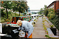
2
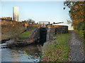
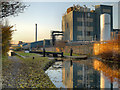
Vinegar Lock, Ashton Canal
Lock#10 on the Ashton Canal at the side of the Anchor Chemicals (now a subsidiary of Air Products) factory is called "Vinegar Lock" from the nearby vinegar works which were demolished in the 1980s.
Lock 10 has the distinction of being the deepest narrow lock in Britain, with a fall of 13 feet 10 inches (http://www.penninewaterways.co.uk/ashton/ac6b.htm Pennine Waterways).
Image: © David Dixon
Taken: 15 Nov 2012
0.13 miles
3
Ashton Canal Lock, Clayton Lane, Clayton
Image: © Peter Whatley
Taken: 24 Jan 2009
0.13 miles
4
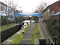
Lock No.10 bottom gates
On the Ashton Canal with one of several chemical works at Clayton alongside
Image: © Kevin Waterhouse
Taken: 24 Feb 2023
0.13 miles
5
Ashton Canal, Lock 10 (Vinegar Lock)
Lock#10 on the Ashton Canal, at the side of the Anchor Chemicals (now a subsidiary of Air Products) factory, is called "Vinegar Lock" from the nearby vinegar works which were demolished in the 1980s.
Lock 10 has the distinction of being the deepest narrow lock in Britain, with a fall of 13 feet 10 inches (http://www.penninewaterways.co.uk/ashton/ac6b.htm Pennine Waterways).
Image: © David Dixon
Taken: 15 Nov 2012
0.14 miles
6
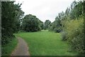
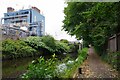
Canalside Open Space in Openshaw
A small "Country Park" by the Ashton Canal.
Image: © Glyn Baker
Taken: 11 Sep 2021
0.14 miles
7
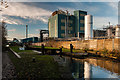
Ashton Canal
Industrial buildings alongside the Ashton Canal.
Image: © Peter McDermott
Taken: 30 Nov 2014
0.14 miles
8
Lock 9 on the Ashton Canal
Looking upstream.
Image: © Glyn Baker
Taken: 11 Sep 2021
0.14 miles
9

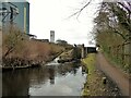
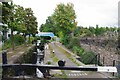
Ashton Canal, Lock#9
Lock 9, Clayton Lane Lock, looking east towards Lock 10 from Six Acre Bridge (Clayton Lane). The lock, which has been partly rebuilt and renovated, was originally built for the Manchester and Ashton-under-Lyne Canal Company ca 1792-1799. It is Grade II-listed (List Entry Number: 1197832 https://historicengland.org.uk/listing/the-list/list-entry/1197832 Historic England).
Image: © David Dixon
Taken: 23 Jul 2021
0.14 miles
10
Lock 9, Ashton Canal, 1990
Lock 10 is in the distance. The paddles had anti-vandal keys, hence the fiddling around in the foreground.
Image: © Robin Webster
Taken: 18 Sep 1990
0.14 miles