IMAGES TAKEN NEAR TO
Greenside Street, MANCHESTER, M11 2FZ
Introduction
This page details the photographs taken nearby to Greenside Street, M11 2FZ by members of the Geograph project.
The Geograph project started in 2005 with the aim of publishing, organising and preserving representative images for every square kilometre of Great Britain, Ireland and the Isle of Man.

There are currently over 7.5m images from over14,400 individuals and you can help contribute to the project by visiting https://www.geograph.org.uk
Image Map
Images are licensed for reuse under creativecommons.org/licenses/by-sa/2.0
Notes
- Clicking on the map will re-center to the selected point.
- The higher the marker number, the further away the image location is from the centre of the postcode.
Image Listing (55 Images Found)
Images are licensed for reuse under creativecommons.org/licenses/by-sa/2.0
Image
Details
Distance
1
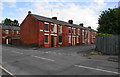
Boarded-up terraces
Between Parkhouse Street and Ashton Old Road, but it is unlikely that there is any immediate alternative development intended for this area.
Image: © Bill Boaden
Taken: 14 Jun 2010
0.06 miles
2
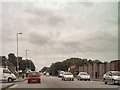
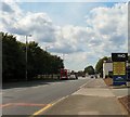
Ashton Old Road (A635)
Passing Greenside Street in Openshaw.
Image: © David Dixon
Taken: 20 Jul 2010
0.07 miles
3
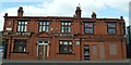
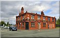
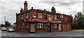
The Queen Anne, Openshaw
A refurbished early 20th century pub situated on A635 Ashton Old Road between Store Street and Bartlett Street in Openshaw.
Image: © Bobby Clegg
Taken: 12 Aug 2015
0.07 miles
4
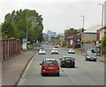
Ashton Old Road
The A635 into Manchester.
Image: © Gerald England
Taken: 13 Jun 2015
0.08 miles
5
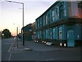
Feeling Blue?
Rundown building at the junction of Bartlett St with Ashton Old Road, Openshaw.
Formerly a public house known as the Drover's Arms. Now (early 2008) being renovated.
Image: © Keith Williamson
Taken: 2 Sep 2005
0.10 miles
6
Ashton Old Road
The A635 into Manchester near the New Smithfield Market.
Image: © Gerald England
Taken: 22 Aug 2009
0.11 miles
7
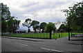
Openshaw Park
The entrance sign is of a design used by Manchester City Council in all their parks. Far left is the Greggs Bakers depot. I think some items are baked there, but others are brought in for distribution.
Image: © Bill Boaden
Taken: 14 Jun 2010
0.11 miles
8
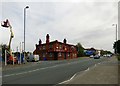
The Queen Anne
The Queen Anne pub on Ashton Old Road, Openshaw.
Research suggests that it was originally called The Lord Wolseley, it re-opened briefly in 2013 after being moth-balled for almost two years and part of the premises are/were used as a "Gentlemen's Club" with an entrance at the rear.
It has an image of Queen Anne/Britannia etched on the glass Image and a Chinese bagua diagram above the doorway Image
Image: © Gerald England
Taken: 28 Sep 2016
0.12 miles
9
The Queen Anne
The former Queen Anne public house, now a restaurant.
Image: © Peter McDermott
Taken: 2 Jul 2019
0.12 miles
10
Ashton Old Road
The A635 through Openshaw. The Real Taste Chinese takeaway on the corner was formerly the Queen Anne Image
Image: © Gerald England
Taken: 6 Aug 2018
0.12 miles