IMAGES TAKEN NEAR TO
Wolverton Street, MANCHESTER, M11 2ET
Introduction
This page details the photographs taken nearby to Wolverton Street, M11 2ET by members of the Geograph project.
The Geograph project started in 2005 with the aim of publishing, organising and preserving representative images for every square kilometre of Great Britain, Ireland and the Isle of Man.

There are currently over 7.5m images from over14,400 individuals and you can help contribute to the project by visiting https://www.geograph.org.uk
Image Map
Images are licensed for reuse under creativecommons.org/licenses/by-sa/2.0
Notes
- Clicking on the map will re-center to the selected point.
- The higher the marker number, the further away the image location is from the centre of the postcode.
Image Listing (73 Images Found)
Images are licensed for reuse under creativecommons.org/licenses/by-sa/2.0
Image
Details
Distance
1
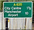
Sign on the A635
The sign at Ashburys Image reads One and half miles to the City Centre and 10 miles to Manchester Airport.
Image: © Gerald England
Taken: 13 Jun 2015
0.05 miles
2
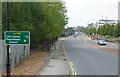
Ashton Old Road, Ashburys
The A635 a mile and a half Image from Manchester City Centre.
Image: © Gerald England
Taken: 13 Jun 2015
0.05 miles
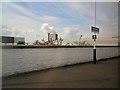
3

Ashton Old Road, Manchester
Strangely not marked as dual carriageway on the OS map. Leering over the city on the horizon is the 551ft-high Beetham Tower, which at the time of this image being taken is the tallest building in the UK outside of London.
Image: © Stephen Sweeney
Taken: 21 Jun 2011
0.08 miles
4
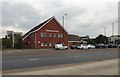
Cornerstone Centre
The family practitioner service on Graham Street across Ashton Old Road was formerly Mill Street Medical Centre http://www.cornerstonefamilypractice.nhs.uk/
Image: © Gerald England
Taken: 6 Aug 2018
0.11 miles
5
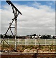
Trackside at Ashburys
In the distance is the City of Manchester stadium in Image
I was asked if I knew what the contraption on the left was used for.
I threw the question open on the Geograph Discussion Forum.
It was suggested that it was possibly used by the travelling post office for dropping off mail bags and picking them up, but that was severely disputed.
Martin Addison http://www.geograph.org.uk/profile/4942 had a feeling that it was a surviving piece of catenary from the original 1500v dc electrification of the 1950s. The attachments in the top left corner carried the support wires, similar fittings on the catenary were seen on the Woodhead line. http://www.derbysulzers.com/woodhead.html
Nigel Cox http://www.geograph.org.uk/profile/2798 suggested that it was more likely to be a gantry that used to hold a height restriction cradle to warn goods train operators with open freight of an overhead restriction ahead, but on reflection agreed with Martin's suggestion, having thought the electricity cables on the gantry were far too over-engineered for what he'd suggested.
Andy F http://www.geograph.org.uk/profile/32299 also agreed that the gantry is part of the ex-GC lines Manchester-Sheffield-Wath electrification scheme. http://en.wikipedia.org/wiki/Manchester-Sheffield-Wath_electric_railway
Image: © Gerald England
Taken: 26 Sep 2009
0.12 miles

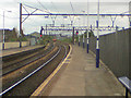
8
Ashburys station
Between Guide Bridge and Manchester Piccadilly.
Image: © Gerald England
Taken: 13 Jul 2017
0.12 miles
9

Ashburys Station
A view of the through lines in 1978 during a photo-stop on a railtour. The sidings on the left formed part of Ardwick East Goods Depot and have since been lifted although the land they occupied remains undeveloped. Evidence of their existence can still be seen in the form of the isolated sections of catenary that stand amongst the young trees that have grown on the land.
The loco is 40170 operating the Northwest Rambler railtour. Class 40's were popular locos on tours at the time as they were being withdrawn from service.
Image: © Martin Addison
Taken: 29 Apr 1978
0.12 miles
10
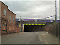
Gorton Road Rail Bridge
The bridge carrying the railway over Gorton Road at Ashbury's West Junction. Seen here from Vaughan Street.
Image: © David Dixon
Taken: 19 May 2010
0.12 miles