IMAGES TAKEN NEAR TO
Harrogate Close, MANCHESTER, M11 1WX
Introduction
This page details the photographs taken nearby to Harrogate Close, M11 1WX by members of the Geograph project.
The Geograph project started in 2005 with the aim of publishing, organising and preserving representative images for every square kilometre of Great Britain, Ireland and the Isle of Man.

There are currently over 7.5m images from over14,400 individuals and you can help contribute to the project by visiting https://www.geograph.org.uk
Image Map
Images are licensed for reuse under creativecommons.org/licenses/by-sa/2.0
Notes
- Clicking on the map will re-center to the selected point.
- The higher the marker number, the further away the image location is from the centre of the postcode.
Image Listing (51 Images Found)
Images are licensed for reuse under creativecommons.org/licenses/by-sa/2.0
Image
Details
Distance
5
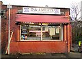
D & J Meats
Butcher's shop on Ogden Lane, Openshaw.
Image: © Gerald England
Taken: 15 Nov 2010
0.15 miles
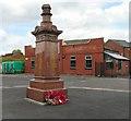
7
Gorton station booking office
Designed to be vandal resistant and fireproof - with good reason.
Image: © Peter Whatley
Taken: 24 Mar 1989
0.15 miles
8
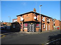
Oddfellows Arms - Higher Openshaw
The Oddfellows Arms is situated on the corner of Stanley Street with Abbey Hey Lane.
Image: © John Topping
Taken: 5 Nov 2012
0.16 miles
9
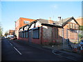
Higher Openshaw Working Men's Club and Institute 1928
Stanley Street/Barber Street.
Image: © John Topping
Taken: 5 Nov 2012
0.17 miles
10
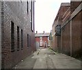
Barber Street
Passageway linking Ashton Old Road with Stanley Road, Openshaw.
Image: © Gerald England
Taken: 7 May 2013
0.17 miles