IMAGES TAKEN NEAR TO
Gransmoor Road, MANCHESTER, M11 1ER
Introduction
This page details the photographs taken nearby to Gransmoor Road, M11 1ER by members of the Geograph project.
The Geograph project started in 2005 with the aim of publishing, organising and preserving representative images for every square kilometre of Great Britain, Ireland and the Isle of Man.

There are currently over 7.5m images from over14,400 individuals and you can help contribute to the project by visiting https://www.geograph.org.uk
Image Map
Images are licensed for reuse under creativecommons.org/licenses/by-sa/2.0
Notes
- Clicking on the map will re-center to the selected point.
- The higher the marker number, the further away the image location is from the centre of the postcode.
Image Listing (86 Images Found)
Images are licensed for reuse under creativecommons.org/licenses/by-sa/2.0
Image
Details
Distance
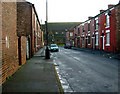
1
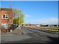
Gransmoor Road - Higher Openshaw
View north from Toxteth Street along Gransmoor Road.
Image: © John Topping
Taken: 5 Nov 2012
0.03 miles
2
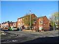
Clement Court ? Adactus Housing Association
Clement Court (sheltered housing) is situated on the corner of Toxteth Street and Cransmoor Road.
Image: © John Topping
Taken: 5 Nov 2012
0.03 miles
3
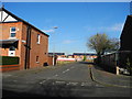
Reginald Street - Higher Openshaw
Seen from Toxteth Street.
Image: © John Topping
Taken: 5 Nov 2012
0.03 miles
4
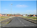
Bowness Street - Higher Openshaw
View north from Toxteth Street.
Image: © John Topping
Taken: 5 Nov 2012
0.04 miles
5
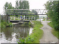
Buxton Lane Swing Bridge, Droylsden
There is a swing bridge and a footbridge across the Ashton Canal at the end of Buxton Lane, in Droylsden.
Image: © Martin Clark
Taken: Unknown
0.06 miles
6
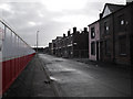
Stopford Street, Openshaw
This large area of old terraced houses is in the process of being demolished. In the past the people who lived here worked in the many large factories that used to be in the area, in more recent times quite a few of them have been occupied by immigrants from many parts of the world. On the other side of the hoarding the redevelopment is under way with the building of new town houses and apartments.
Image: © Stephen Burton
Taken: 26 Mar 2010
0.06 miles
7
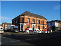
Furniture and Appliance Store
The building (on the corner of Ashton Old Road with Gransmoor Road) was formerly the Gransmoor Hotel (closed in the late 1990s or early 2000s?) and is now a furniture and appliance store.
Image: © John Topping
Taken: 5 Nov 2012
0.06 miles
8
Silverdale Street - Higher Openshaw
View north from Toxteth Street.
Image: © John Topping
Taken: 5 Nov 2012
0.07 miles
9
South Cliff Street
Looking along South Cliff Street towards the junction with Toxteth Street. At the end of the street is the back of St. Clements Church of England the front of the church is on Ashton Old Road. Plans are in the pipeline to redevelop this area of Manchester at present many of the homes are empty.
Image: © Stephen Burton
Taken: 22 Feb 2007
0.07 miles
10
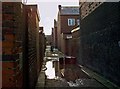
Back Alleyway
Back alleyway in a semi-derelict area of Openshaw.
Image: © Stephen Burton
Taken: 14 Mar 2008
0.07 miles