IMAGES TAKEN NEAR TO
The Lynch, DUNSTABLE, LU6 3QZ
Introduction
This page details the photographs taken nearby to The Lynch, LU6 3QZ by members of the Geograph project.
The Geograph project started in 2005 with the aim of publishing, organising and preserving representative images for every square kilometre of Great Britain, Ireland and the Isle of Man.

There are currently over 7.5m images from over14,400 individuals and you can help contribute to the project by visiting https://www.geograph.org.uk
Image Map
Images are licensed for reuse under creativecommons.org/licenses/by-sa/2.0
Notes
- Clicking on the map will re-center to the selected point.
- The higher the marker number, the further away the image location is from the centre of the postcode.
Image Listing (5 Images Found)
Images are licensed for reuse under creativecommons.org/licenses/by-sa/2.0
Image
Details
Distance
2
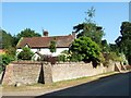
Cottage, Kensworth Lynch
A charming cottage in Kensworth Lynch. The owner (who can just be seen) asked why I was taking photos and seemed interested when I told him it was for this website - perhaps he'll go online and find this picture.
Image: © Rob Farrow
Taken: 28 Jun 2006
0.05 miles
3
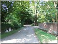
Footpath, Kensworth Lynch
This quite wide track is the start of a footpath leading out of Kensworth Lynch in a roughly north-easterly direction. Looking at the map, it seems to hit the A5 Watling Street right by a pub - which may well explain its existence.
Image: © Rob Farrow
Taken: 28 Jun 2006
0.05 miles
4
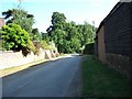
Kensworth Lynch
A view down the lane through Kensworth Lynch, Image is to the left, while Corner Farm is on the right.
Image: © Rob Farrow
Taken: 28 Jun 2006
0.05 miles
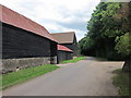
5
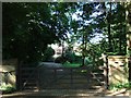
Lynch Farm, Kensworth Lynch
The farm itself is just visible in the middle of the picture, though doing its best to be obscured by bushes. I do not know the derivation of "Lynch" for sure, but I suspect that rather than referring to illegal execution, that it may have come from lynchet - "a ridge or ledge formed by ancient ploughing on a slope." [OED definition]
Image: © Rob Farrow
Taken: 28 Jun 2006
0.16 miles