IMAGES TAKEN NEAR TO
Burges Close, DUNSTABLE, LU6 3EU
Introduction
This page details the photographs taken nearby to Burges Close, LU6 3EU by members of the Geograph project.
The Geograph project started in 2005 with the aim of publishing, organising and preserving representative images for every square kilometre of Great Britain, Ireland and the Isle of Man.

There are currently over 7.5m images from over14,400 individuals and you can help contribute to the project by visiting https://www.geograph.org.uk
Image Map
Images are licensed for reuse under creativecommons.org/licenses/by-sa/2.0
Notes
- Clicking on the map will re-center to the selected point.
- The higher the marker number, the further away the image location is from the centre of the postcode.
Image Listing (18 Images Found)
Images are licensed for reuse under creativecommons.org/licenses/by-sa/2.0
Image
Details
Distance
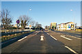
3
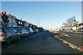
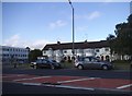
A5183 London Road, Dunstable
Watling Street, a Roman Road, formerly the A5.
Image: © Robin Webster
Taken: 7 Jan 2018
0.17 miles
5
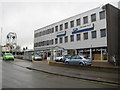
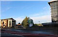
Dunstable: Hartwell Ford vehicle dealers
This was taken looking up Mayfield Road towards the A5 London Road with the prominent dealership clock tower on the corner.
Image: © Nigel Cox
Taken: 11 Jan 2008
0.19 miles
10
A5183 London Road, Dunstable
Watling Street, a Roman Road, formerly the A5.
Image: © Robin Webster
Taken: 7 Jan 2018
0.20 miles