IMAGES TAKEN NEAR TO
Printers Way, DUNSTABLE, LU6 2UT
Introduction
This page details the photographs taken nearby to Printers Way, LU6 2UT by members of the Geograph project.
The Geograph project started in 2005 with the aim of publishing, organising and preserving representative images for every square kilometre of Great Britain, Ireland and the Isle of Man.

There are currently over 7.5m images from over14,400 individuals and you can help contribute to the project by visiting https://www.geograph.org.uk
Image Map
Images are licensed for reuse under creativecommons.org/licenses/by-sa/2.0
Notes
- Clicking on the map will re-center to the selected point.
- The higher the marker number, the further away the image location is from the centre of the postcode.
Image Listing (28 Images Found)
Images are licensed for reuse under creativecommons.org/licenses/by-sa/2.0
Image
Details
Distance
1
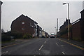
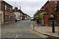
Dunstable : Park Street
A one way road off of High Street North.
Image: © Lewis Clarke
Taken: 25 Mar 2018
0.13 miles
2
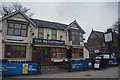
Dunstable : The Wheatsheaf
A pub on High Street North.
Image: © Lewis Clarke
Taken: 25 Mar 2018
0.13 miles
3
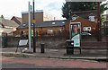
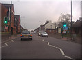
Bus stop on High Street North, Dunstable
Image: © David Howard
Taken: 27 Jun 2020
0.15 miles
4

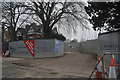
Dunstable : Ashton Middle School
The site of Ashton Middle School is now to become a new development of 113 homes and apartments.
Image: © Lewis Clarke
Taken: 25 Mar 2018
0.15 miles
5
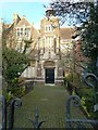
Ashton Middle School, Dunstable
The front entrance of the school. When I started here in 1957 it was the Ashton Grammar School and this was the staff entrance. To the right of this was the Headmasters study and beyond that Headmasters house.
Image: © Paul Buckingham
Taken: 3 Dec 2011
0.15 miles
8
Dunstable : Ashton Middle School
The site of Ashton Middle School is now to become a new development of 113 homes and apartments.
Image: © Lewis Clarke
Taken: 25 Mar 2018
0.18 miles
9

Grove Park, Dunstable
Grove Park is the name given to the retail and office complex adjacent to Grove House Gardens, It includes the studios of BBC Three Counties Radio (the three counties are Bedfordshire, Buckinghamshire and Hertfordshire), seen here on the right and the Grove Theatre at the end of the block. The BBC relocated here from Luton in 2015.
Image: © Stephen McKay
Taken: 27 Oct 2017
0.18 miles
10
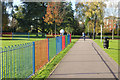
Grove House Gardens
Colourful railings fence off a children's play area in this small town centre park. The gardens were originally part of the private gardens of Grove House; they are now managed by Dunstable Town Council.
Image: © Stephen McKay
Taken: 27 Oct 2017
0.19 miles