IMAGES TAKEN NEAR TO
Grove Place, DUNSTABLE, LU6 2ST
Introduction
This page details the photographs taken nearby to Grove Place, LU6 2ST by members of the Geograph project.
The Geograph project started in 2005 with the aim of publishing, organising and preserving representative images for every square kilometre of Great Britain, Ireland and the Isle of Man.

There are currently over 7.5m images from over14,400 individuals and you can help contribute to the project by visiting https://www.geograph.org.uk
Image Map
Images are licensed for reuse under creativecommons.org/licenses/by-sa/2.0
Notes
- Clicking on the map will re-center to the selected point.
- The higher the marker number, the further away the image location is from the centre of the postcode.
Image Listing (16 Images Found)
Images are licensed for reuse under creativecommons.org/licenses/by-sa/2.0
Image
Details
Distance
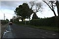
1
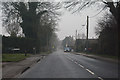
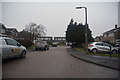
Kensworth : Common Road B4540
A road heading through the village of Kensworth.
Image: © Lewis Clarke
Taken: 24 Mar 2018
0.04 miles
2
Kensworth : Poplar Road
A road heading off from Common Road.
Image: © Lewis Clarke
Taken: 24 Mar 2018
0.09 miles
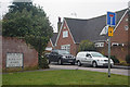
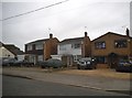
3
Kensworth : Maple Way
A residential road off Poplar Road.
Image: © Lewis Clarke
Taken: 24 Mar 2018
0.11 miles
4
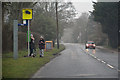
Kensworth : Common Road B4540
Some youngsters waiting at a bus stop in Kensworth.
Image: © Lewis Clarke
Taken: 24 Mar 2018
0.12 miles
5
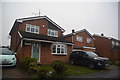
Kensworth : Poplar Road
Houses on Poplar Road in the village of Kensworth.
Image: © Lewis Clarke
Taken: 24 Mar 2018
0.13 miles
9
Kensworth : Green Lane
A small residential road off of Poplar Road.
Image: © Lewis Clarke
Taken: 24 Mar 2018
0.18 miles
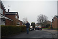
10
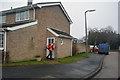
Kensworth : Poplar Road
The postman is delivering his letters at Poplar Road.
Image: © Lewis Clarke
Taken: 24 Mar 2018
0.19 miles