IMAGES TAKEN NEAR TO
Buckwood Lane, DUNSTABLE, LU6 2PG
Introduction
This page details the photographs taken nearby to Buckwood Lane, LU6 2PG by members of the Geograph project.
The Geograph project started in 2005 with the aim of publishing, organising and preserving representative images for every square kilometre of Great Britain, Ireland and the Isle of Man.

There are currently over 7.5m images from over14,400 individuals and you can help contribute to the project by visiting https://www.geograph.org.uk
Image Map
Images are licensed for reuse under creativecommons.org/licenses/by-sa/2.0
Notes
- Clicking on the map will re-center to the selected point.
- The higher the marker number, the further away the image location is from the centre of the postcode.
Image Listing (6 Images Found)
Images are licensed for reuse under creativecommons.org/licenses/by-sa/2.0
Image
Details
Distance
3
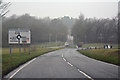
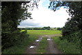
Central Bedfordshire : Common Road B4545
Approaching Whipsnade Crossroads on the B4540.
Image: © Lewis Clarke
Taken: 24 Mar 2018
0.22 miles
4
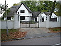
Woodlands - Studham
I believe that this may be a "modern traditional cottage". Firstly it is very big for the age that it would appear to be and secondly, it doesn't appear on the 1940's OS map of the area.
Image: © Robin Hall
Taken: 22 Oct 2005
0.23 miles
5
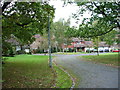
Holywell
Large houses in a relatively modern estate in a relatively modern village. From what I could see this village lacks most of the things that define a village, pub church, shop, cricket pitch. Ah nostalgia ain't what it used to be.
Image: © Robin Hall
Taken: 22 Oct 2005
0.23 miles
6
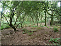
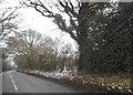
Whipsnade Heath woodland
Secondary woodland covering a great many small humps and hollows. Something has been delved for here in the past.
Image: © Robin Webster
Taken: 19 Sep 2015
0.24 miles