IMAGES TAKEN NEAR TO
Whipsnade, DUNSTABLE, LU6 2LL
Introduction
This page details the photographs taken nearby to LU6 2LL by members of the Geograph project.
The Geograph project started in 2005 with the aim of publishing, organising and preserving representative images for every square kilometre of Great Britain, Ireland and the Isle of Man.

There are currently over 7.5m images from over14,400 individuals and you can help contribute to the project by visiting https://www.geograph.org.uk
Image Map
Images are licensed for reuse under creativecommons.org/licenses/by-sa/2.0
Notes
- Clicking on the map will re-center to the selected point.
- The higher the marker number, the further away the image location is from the centre of the postcode.
Image Listing (48 Images Found)
Images are licensed for reuse under creativecommons.org/licenses/by-sa/2.0
Image
Details
Distance
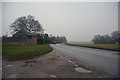
2
Whipsnade : Lane
A small lane heading off from the B4540.
Image: © Lewis Clarke
Taken: 24 Mar 2018
0.03 miles
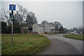
3
Whipsnade : The B4540
Joining the B4540 from Bushey Close.
Image: © Lewis Clarke
Taken: 24 Mar 2018
0.03 miles
4
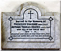
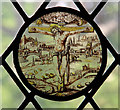
St Mary Magdalene, Whipsnade - Wall monument WWI
Image: © John Salmon
Taken: 17 Jun 2016
0.04 miles
5
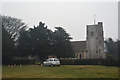
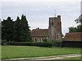
Whipsnade : St Mary Magdalene
From the road looking across to the church.
Image: © Lewis Clarke
Taken: 24 Mar 2018
0.04 miles
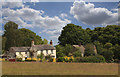
7
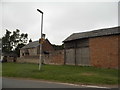
Farm buildings on Common Road, Whipsnade
Image: © David Howard
Taken: 19 Jul 2017
0.04 miles
8
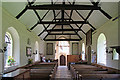
St Mary Magdalene, Whipsnade - West end
Image: © John Salmon
Taken: 17 Jun 2016
0.04 miles
10

St Mary Magdalene, Whipsnade - Royal Arms
Image: © John Salmon
Taken: 17 Jun 2016
0.04 miles