IMAGES TAKEN NEAR TO
Maypole Yard, West Street, DUNSTABLE, LU6 1XF
Introduction
This page details the photographs taken nearby to Maypole Yard, West Street, LU6 1XF by members of the Geograph project.
The Geograph project started in 2005 with the aim of publishing, organising and preserving representative images for every square kilometre of Great Britain, Ireland and the Isle of Man.

There are currently over 7.5m images from over14,400 individuals and you can help contribute to the project by visiting https://www.geograph.org.uk
Image Map
Images are licensed for reuse under creativecommons.org/licenses/by-sa/2.0
Notes
- Clicking on the map will re-center to the selected point.
- The higher the marker number, the further away the image location is from the centre of the postcode.
Image Listing (198 Images Found)
Images are licensed for reuse under creativecommons.org/licenses/by-sa/2.0
Image
Details
Distance
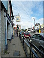
1
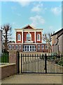
West Street Baptist Church, Dunstable
Image: © Paul Buckingham
Taken: 3 Dec 2011
0.01 miles
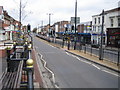
3
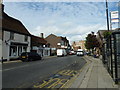
Looking east-northeast along West Street
Image: © Basher Eyre
Taken: 8 Sep 2011
0.02 miles
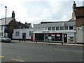
7
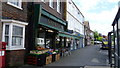
Lombardo's shop in Dunstable
An Italian coffee shop, deli and general store in one I suppose. A cracker.
Image: © Jeremy Bolwell
Taken: 5 Jun 2014
0.03 miles
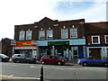
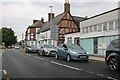
9
Dunstable: The A5 High Street (North)
Viewed looking north westwards up the former Watling Street.
Image: © Nigel Cox
Taken: 2 Apr 2006
0.04 miles
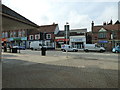
10
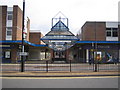
Dunstable: The Quadrant Shopping Centre
The west entrance to The Quadrant Shopping Centre, originally opened in 1966, on the A5 High Street (North).
Image: © Nigel Cox
Taken: 2 Apr 2006
0.04 miles