IMAGES TAKEN NEAR TO
Cusworth Walk, DUNSTABLE, LU6 1UE
Introduction
This page details the photographs taken nearby to Cusworth Walk, LU6 1UE by members of the Geograph project.
The Geograph project started in 2005 with the aim of publishing, organising and preserving representative images for every square kilometre of Great Britain, Ireland and the Isle of Man.

There are currently over 7.5m images from over14,400 individuals and you can help contribute to the project by visiting https://www.geograph.org.uk
Image Map
Images are licensed for reuse under creativecommons.org/licenses/by-sa/2.0
Notes
- Clicking on the map will re-center to the selected point.
- The higher the marker number, the further away the image location is from the centre of the postcode.
Image Listing (7 Images Found)
Images are licensed for reuse under creativecommons.org/licenses/by-sa/2.0
Image
Details
Distance
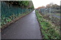
1
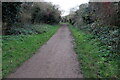
Cycle route heading for Leighton Buzzard
Image: © Philip Jeffrey
Taken: 20 Dec 2020
0.17 miles
2
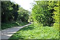
The Greenway
A view of the end of Sewell Cutting Greenway near French's Avenue. This path follows the course of the old Dunstable North to Leighton Buzzard railway branch line.
Image: © Bob Walters
Taken: 21 Apr 2022
0.17 miles
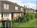
4
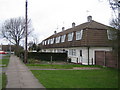
Dunstable: Aldbanks
Council-built houses with mansard roofs, typical of many in the area.
Image: © Nigel Cox
Taken: 2 Apr 2006
0.22 miles
5
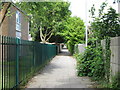
Alley by Weatherfield School
Leading through to houses on Saxon and Greenfield Closes.
Image: © M J Richardson
Taken: 19 Jun 2011
0.24 miles
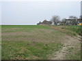
6
Cycle route by Dunstable Football ground
Image: © Philip Jeffrey
Taken: 20 Dec 2020
0.24 miles
7
Houses on Brewers Hill Road, Dunstable
Image: © M J Richardson
Taken: 19 Jun 2011
0.25 miles