IMAGES TAKEN NEAR TO
Chalk Hill, DUNSTABLE, LU6 1RT
Introduction
This page details the photographs taken nearby to Chalk Hill, LU6 1RT by members of the Geograph project.
The Geograph project started in 2005 with the aim of publishing, organising and preserving representative images for every square kilometre of Great Britain, Ireland and the Isle of Man.

There are currently over 7.5m images from over14,400 individuals and you can help contribute to the project by visiting https://www.geograph.org.uk
Image Map
Images are licensed for reuse under creativecommons.org/licenses/by-sa/2.0
Notes
- Clicking on the map will re-center to the selected point.
- The higher the marker number, the further away the image location is from the centre of the postcode.
Image Listing (11 Images Found)
Images are licensed for reuse under creativecommons.org/licenses/by-sa/2.0
Image
Details
Distance
3
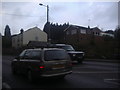
Houses on Watling Street, Chalk Hill
Chalk Hill is a huge outcrop from the Dunstable Downs on the right of Watling Street going south
Image: © David Howard
Taken: 4 Apr 2012
0.04 miles
4
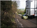
Chiltern Way Chalk Hill
Chiltern Way turns to the right after the white house at Chalk Hill
Image: © Shaun Ferguson
Taken: 23 Mar 2010
0.04 miles
5
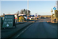
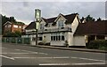
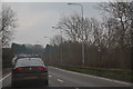
A5183 Watling Street (Roman Road) heading north
Formerly the A5. Sunday lunches are at the White Lion pub.
Image: © Robin Webster
Taken: 7 Jan 2018
0.04 miles
6
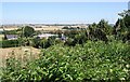
Puddlehill or Chalk Hill
On the 1940s maps this area on the A5 to the west of Dunstable is called Puddlehill, but on current maps it is called Chalk Hill. This photograph was taken from the lane to Sewell on the southern side of the A5 looking across country towards Thorn. The building in the centre of the image is a Q8 garage on the A5 Watling Street.
Image: © Rob Farrow
Taken: 18 Jul 2006
0.06 miles
7
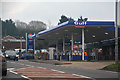
Dunstable : Gulf Petrol Station
A Gulf petrol station on Watling Street just north of Dunstable.
Image: © Lewis Clarke
Taken: 25 Mar 2018
0.06 miles
8
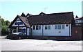
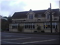
The Chalk Hill
This is the eponymously named Chalk Hill public house in Chalk Hill - though the 1940s map refers to this area as Puddlehill. It is on the busy A5 near Dunstable, but does have a large carpark.
Image: © Rob Farrow
Taken: 18 Jul 2006
0.10 miles
10
Central Bedfordshire : Watling Street, A505
Looking along the A505 heading into Dunstable.
Image: © Lewis Clarke
Taken: 25 Mar 2018
0.21 miles