IMAGES TAKEN NEAR TO
Beale Street, DUNSTABLE, LU6 1JS
Introduction
This page details the photographs taken nearby to Beale Street, LU6 1JS by members of the Geograph project.
The Geograph project started in 2005 with the aim of publishing, organising and preserving representative images for every square kilometre of Great Britain, Ireland and the Isle of Man.

There are currently over 7.5m images from over14,400 individuals and you can help contribute to the project by visiting https://www.geograph.org.uk
Image Map
Images are licensed for reuse under creativecommons.org/licenses/by-sa/2.0
Notes
- Clicking on the map will re-center to the selected point.
- The higher the marker number, the further away the image location is from the centre of the postcode.
Image Listing (32 Images Found)
Images are licensed for reuse under creativecommons.org/licenses/by-sa/2.0
Image
Details
Distance
1
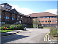
Dunstable: South Bedfordshire District Council offices
South Bedfordshire District Council was formed in 1974 by the amalgamation of three existing authorities, Dunstable Municipal Borough Council, Leighton-Linslade Urban District Council and Luton Rural District Council. The building occupies the site of the former Dunstable North railway station.
Image: © Nigel Cox
Taken: 2 Apr 2006
0.09 miles
5
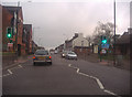
Site of Dunstable North Station
Central Bedfordshire Council offices now occupy the site of the old Dunstable North Station. It was on the L&NWR branch from Leighton Buzzard and connected to the GNR branch onwards to Luton and Hatfield. There was a bridge over the A5 in the foreground below the council sign; the road still dips where it once was.
Image: © Bob Walters
Taken: 26 Apr 2022
0.15 miles
6

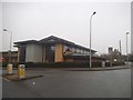
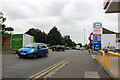
Dunstable : Esso Petrol Station
An Esso Petrol Station on High Street North.
Image: © Lewis Clarke
Taken: 25 Mar 2018
0.16 miles
8
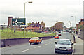
NW on A5 at site of former Dunstable North station, 1990
View NW on A5 towards Milton Keynes. The ex-LNWR line from Leighton Buzzard (to right) had crossed here to enter Dunstable North station (up to the left), then joining end-on with the ex-GNR line from Hatfield and Welwyn Garden City via Luton and Dunstable Town (see Image]). The line from Leighton Buzzard was closed 10/1/66, passenger services having ceased 2/7/62, those from Hatfield from 26/4/65, but goods from Hatfield continued until 9/10/67. (My Honda Accord features in the foreground).
Image: © Ben Brooksbank
Taken: 4 Nov 1990
0.17 miles
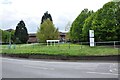
9

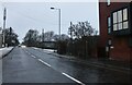
Dunstable : Avenue
A small avenue off of High Street North.
Image: © Lewis Clarke
Taken: 25 Mar 2018
0.17 miles