IMAGES TAKEN NEAR TO
Chiltern Gardens, Waller Avenue, LUTON, LU4 9RL
Introduction
This page details the photographs taken nearby to Chiltern Gardens, Waller Avenue, LU4 9RL by members of the Geograph project.
The Geograph project started in 2005 with the aim of publishing, organising and preserving representative images for every square kilometre of Great Britain, Ireland and the Isle of Man.

There are currently over 7.5m images from over14,400 individuals and you can help contribute to the project by visiting https://www.geograph.org.uk
Image Map
Images are licensed for reuse under creativecommons.org/licenses/by-sa/2.0
Notes
- Clicking on the map will re-center to the selected point.
- The higher the marker number, the further away the image location is from the centre of the postcode.
Image Listing (7 Images Found)
Images are licensed for reuse under creativecommons.org/licenses/by-sa/2.0
Image
Details
Distance
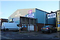
2
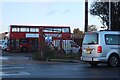
Bus depot on Waller Avenue, Luton
I'd say the bus is well over 20 years old but didn't see the number plate for the exact date.
Image: © David Howard
Taken: 6 Nov 2022
0.11 miles
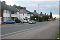
3
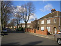
Luton: Dordans Road
This is the only road in the UK with this name. The 1888 Ordnance Survey map shows this whole area as open fields either side of the Midland Railway line.
Image: © Nigel Cox
Taken: 23 Jan 2007
0.16 miles
7
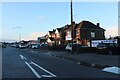
Selbourne Road, Luton
This road runs along the railway line on the right.
Image: © David Howard
Taken: 6 Nov 2022
0.25 miles