IMAGES TAKEN NEAR TO
Addington Way, LUTON, LU4 9FJ
Introduction
This page details the photographs taken nearby to Addington Way, LU4 9FJ by members of the Geograph project.
The Geograph project started in 2005 with the aim of publishing, organising and preserving representative images for every square kilometre of Great Britain, Ireland and the Isle of Man.

There are currently over 7.5m images from over14,400 individuals and you can help contribute to the project by visiting https://www.geograph.org.uk
Image Map
Images are licensed for reuse under creativecommons.org/licenses/by-sa/2.0
Notes
- Clicking on the map will re-center to the selected point.
- The higher the marker number, the further away the image location is from the centre of the postcode.
Image Listing (12 Images Found)
Images are licensed for reuse under creativecommons.org/licenses/by-sa/2.0
Image
Details
Distance
1
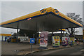
Luton : Jet Petrol Station
A petrol station off of High Street.
Image: © Lewis Clarke
Taken: 25 Mar 2018
0.15 miles
2
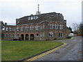
Parish Church of St Luke
Parish Church of St Luke Leagrave off High Street
Image: © Shaun Ferguson
Taken: 23 Mar 2010
0.17 miles
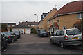
3
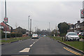
Luton : Mayne Avenue
Looking along Mayne Avenue in Luton.
Image: © Lewis Clarke
Taken: 25 Mar 2018
0.18 miles
4
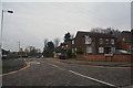
Luton : Strangers Way
Looking along Strangers Way off of the High Street.
Image: © Lewis Clarke
Taken: 25 Mar 2018
0.19 miles
5
Luton : Milligan Close
A small residential street off Linden Road.
Image: © Lewis Clarke
Taken: 25 Mar 2018
0.22 miles

9
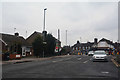
Luton : High Street
Looking along High Street in the Leagrave area of Luton.
Image: © Lewis Clarke
Taken: 25 Mar 2018
0.24 miles
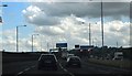
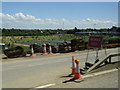
10
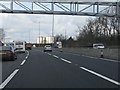
M1 motorway - roadworks north of junction 11
Image: © Peter Whatley
Taken: 3 Apr 2012
0.24 miles