IMAGES TAKEN NEAR TO
Dalby Close, LUTON, LU4 0XF
Introduction
This page details the photographs taken nearby to Dalby Close, LU4 0XF by members of the Geograph project.
The Geograph project started in 2005 with the aim of publishing, organising and preserving representative images for every square kilometre of Great Britain, Ireland and the Isle of Man.

There are currently over 7.5m images from over14,400 individuals and you can help contribute to the project by visiting https://www.geograph.org.uk
Image Map
Images are licensed for reuse under creativecommons.org/licenses/by-sa/2.0
Notes
- Clicking on the map will re-center to the selected point.
- The higher the marker number, the further away the image location is from the centre of the postcode.
Image Listing (9 Images Found)
Images are licensed for reuse under creativecommons.org/licenses/by-sa/2.0
Image
Details
Distance
1
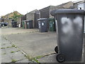
Hebden Close
Wheelie bins in Leagrave.
Image: © Burgess Von Thunen
Taken: 18 Oct 2012
0.08 miles
2
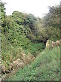
Leagrave
An overgrown stream in Luton.
Image: © Burgess Von Thunen
Taken: 18 Oct 2012
0.10 miles
3
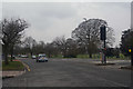
Luton : Leagrave High Street
Looking along Leagrave High Street.
Image: © Lewis Clarke
Taken: 25 Mar 2018
0.13 miles
5
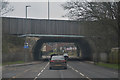
Luton : High Street
Looking along the High Street as it goes underneath the M1 Motorway.
Image: © Lewis Clarke
Taken: 25 Mar 2018
0.18 miles
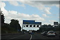
7
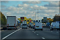
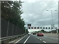
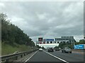
Luton : M1 Motorway
The M1 Motorway between Junction 11a and Junction 11.
Image: © Lewis Clarke
Taken: 3 Oct 2018
0.19 miles
9
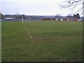
Ferrars Junior school playing fields
Ferrars Junior school playing fields off Lewsey Road
Image: © Shaun Ferguson
Taken: 23 Mar 2010
0.25 miles