IMAGES TAKEN NEAR TO
Tomlinson Avenue, LUTON, LU4 0QN
Introduction
This page details the photographs taken nearby to Tomlinson Avenue, LU4 0QN by members of the Geograph project.
The Geograph project started in 2005 with the aim of publishing, organising and preserving representative images for every square kilometre of Great Britain, Ireland and the Isle of Man.

There are currently over 7.5m images from over14,400 individuals and you can help contribute to the project by visiting https://www.geograph.org.uk
Image Map
Images are licensed for reuse under creativecommons.org/licenses/by-sa/2.0
Notes
- Clicking on the map will re-center to the selected point.
- The higher the marker number, the further away the image location is from the centre of the postcode.
Image Listing (9 Images Found)
Images are licensed for reuse under creativecommons.org/licenses/by-sa/2.0
Image
Details
Distance
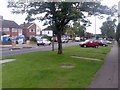
1
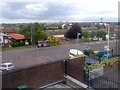
Haymarket Road (back of pub)
This bit is just behind St Dominic Sq
Image: © daniel scotcher
Taken: 2 Jul 2007
0.17 miles
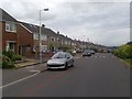
2

Luton: Hereford Road, Lewsey Farm
Viewed looking westwards from the junction with Pastures Way.
Image: © Nigel Cox
Taken: 5 Jan 2006
0.18 miles
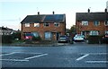
5

Poynters Road, Dunstable
Traffic in a suburb of Dunstable
Image: © D Leonard
Taken: 26 Jun 2019
0.20 miles