IMAGES TAKEN NEAR TO
Cresswell Gardens, LUTON, LU3 4EX
Introduction
This page details the photographs taken nearby to Cresswell Gardens, LU3 4EX by members of the Geograph project.
The Geograph project started in 2005 with the aim of publishing, organising and preserving representative images for every square kilometre of Great Britain, Ireland and the Isle of Man.

There are currently over 7.5m images from over14,400 individuals and you can help contribute to the project by visiting https://www.geograph.org.uk
Image Map
Images are licensed for reuse under creativecommons.org/licenses/by-sa/2.0
Notes
- Clicking on the map will re-center to the selected point.
- The higher the marker number, the further away the image location is from the centre of the postcode.
Image Listing (10 Images Found)
Images are licensed for reuse under creativecommons.org/licenses/by-sa/2.0
Image
Details
Distance
1
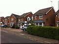
Chard Drive
1990s houses in Luton.
Image: © Burgess Von Thunen
Taken: 13 Aug 2013
0.04 miles
3
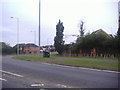
Barton Road by Quantock Rise, Luton
Approaching the Turnpike Roundabout
Image: © David Howard
Taken: 17 Aug 2011
0.17 miles
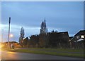
5
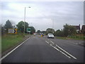
The A6 at the junction of Enterprise Way, Luton
Image: © David Howard
Taken: 17 Aug 2011
0.20 miles
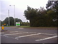
7
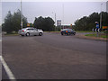
Roundabout on the A6 and Icknield Way, Luton
Image: © David Howard
Taken: 17 Aug 2011
0.21 miles
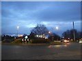
8
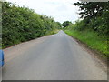
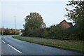
Great Bramingham Lane
All the way to the Barton Road. The houses in the distance are on the Turnpike estate Luton.
Image: © Raymond Cubberley
Taken: 21 Jul 2012
0.23 miles