IMAGES TAKEN NEAR TO
Sharples Green, LUTON, LU3 4BB
Introduction
This page details the photographs taken nearby to Sharples Green, LU3 4BB by members of the Geograph project.
The Geograph project started in 2005 with the aim of publishing, organising and preserving representative images for every square kilometre of Great Britain, Ireland and the Isle of Man.

There are currently over 7.5m images from over14,400 individuals and you can help contribute to the project by visiting https://www.geograph.org.uk
Image Map
Images are licensed for reuse under creativecommons.org/licenses/by-sa/2.0
Notes
- Clicking on the map will re-center to the selected point.
- The higher the marker number, the further away the image location is from the centre of the postcode.
Image Listing (7 Images Found)
Images are licensed for reuse under creativecommons.org/licenses/by-sa/2.0
Image
Details
Distance
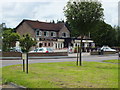
2
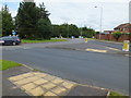
New bold Road Traffic island
Linking quantock rise,Newbold road and Leamington road,Bramingham district,Luton
Image: © Raymond Cubberley
Taken: 21 Jul 2012
0.15 miles
3
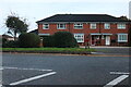
Morrell Close
Small Close in The Bramingham area of Luton
Image: © Raymond Cubberley
Taken: 21 Jul 2012
0.18 miles
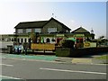
4
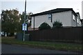
The Jolly Milliner
Same Public house new name in a previous life this was THE BOATER.
At the Junction of Icknield Way and Laburnum Grove.
Image: © Raymond Cubberley
Taken: 21 Jul 2012
0.18 miles
6
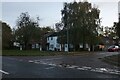
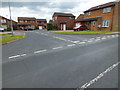
Celandine Drive, Warden Hill
From Whitehorse Vale
Image: © David Howard
Taken: 6 Nov 2022
0.21 miles