IMAGES TAKEN NEAR TO
Harding Close, LUTON, LU3 3NA
Introduction
This page details the photographs taken nearby to Harding Close, LU3 3NA by members of the Geograph project.
The Geograph project started in 2005 with the aim of publishing, organising and preserving representative images for every square kilometre of Great Britain, Ireland and the Isle of Man.

There are currently over 7.5m images from over14,400 individuals and you can help contribute to the project by visiting https://www.geograph.org.uk
Image Map
Images are licensed for reuse under creativecommons.org/licenses/by-sa/2.0
Notes
- Clicking on the map will re-center to the selected point.
- The higher the marker number, the further away the image location is from the centre of the postcode.
Image Listing (4 Images Found)
Images are licensed for reuse under creativecommons.org/licenses/by-sa/2.0
Image
Details
Distance
1
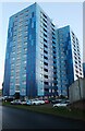
Blue flats on Henge Way, Luton
These were cream and brown but have had a makeover.
Image: © David Howard
Taken: 6 Nov 2022
0.07 miles
2
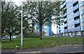
Blue flats on Henge Way, Luton
Once cream and brown.
Image: © David Howard
Taken: 6 Nov 2022
0.08 miles
3
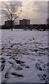
Penhill flats, Marsh Farm, Luton
Penhill on the right is one of the three tower blocks on Marsh Farm, Luton, as seen from the edge of Freeman's Green
Image: © designerx
Taken: 2 Jan 2004
0.14 miles