IMAGES TAKEN NEAR TO
Dray Gardens, LUTON, LU3 3FF
Introduction
This page details the photographs taken nearby to Dray Gardens, LU3 3FF by members of the Geograph project.
The Geograph project started in 2005 with the aim of publishing, organising and preserving representative images for every square kilometre of Great Britain, Ireland and the Isle of Man.

There are currently over 7.5m images from over14,400 individuals and you can help contribute to the project by visiting https://www.geograph.org.uk
Image Map
Images are licensed for reuse under creativecommons.org/licenses/by-sa/2.0
Notes
- Clicking on the map will re-center to the selected point.
- The higher the marker number, the further away the image location is from the centre of the postcode.
Image Listing (18 Images Found)
Images are licensed for reuse under creativecommons.org/licenses/by-sa/2.0
Image
Details
Distance
1

The Pasque Flower
This flower is adopted by the local Pasque Hospice.
Image: © John Yaxley
Taken: 15 Apr 2007
0.01 miles
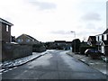
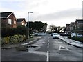
4
Housing bordering open country in TL0826
Early evening looking North/North West
Image: © John Yaxley
Taken: 5 Apr 2007
0.09 miles
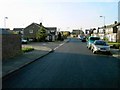
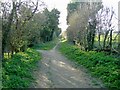
6
Looking East towards Drays Ditches
Just 0.5km off the A6 heading East
Image: © John Yaxley
Taken: 5 Apr 2007
0.11 miles
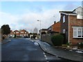
7
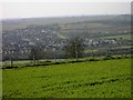
Housing on the very northern edge of Luton
Photographed from the triangulation point on Warden Hill
Image: © John Yaxley
Taken: 6 Apr 2007
0.11 miles
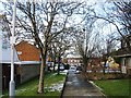
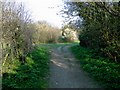
8
Path leading to the A6 from TL0826
Public right of way joining the A6 to Drays Ditches (early Spring evening)
Image: © John Yaxley
Taken: 5 Apr 2007
0.12 miles
9
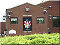
South Beds Golf Club
Never saw the point in it as a sport myself.
Image: © Dennis simpson
Taken: 25 May 2009
0.12 miles