IMAGES TAKEN NEAR TO
Fourth Avenue, LUTON, LU3 3BS
Introduction
This page details the photographs taken nearby to Fourth Avenue, LU3 3BS by members of the Geograph project.
The Geograph project started in 2005 with the aim of publishing, organising and preserving representative images for every square kilometre of Great Britain, Ireland and the Isle of Man.

There are currently over 7.5m images from over14,400 individuals and you can help contribute to the project by visiting https://www.geograph.org.uk
Image Map
Images are licensed for reuse under creativecommons.org/licenses/by-sa/2.0
Notes
- Clicking on the map will re-center to the selected point.
- The higher the marker number, the further away the image location is from the centre of the postcode.
Image Listing (7 Images Found)
Images are licensed for reuse under creativecommons.org/licenses/by-sa/2.0
Image
Details
Distance
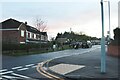
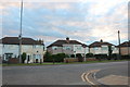
1
Luton: Sundon Park Parade
Community shops in Sundon Park.
Image: © Nigel Cox
Taken: 23 Jan 2007
0.12 miles
2
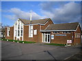
Luton: Sundon Park Baptist Church
The Church is at 244 Sundon Park Road, and has a website here http://www.sundonparkchurch.co.uk/
Image: © Nigel Cox
Taken: 23 Jan 2007
0.16 miles
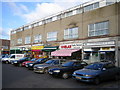
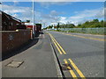
3
Luton: Sundon Park , local shops
Just part of the varied amount of shops in the area.
Image: © Raymond Cubberley
Taken: 29 Jul 2012
0.16 miles
5
Luton: Park Avenue, Sundon Park
Large industrial estate on part of the old Skefko works.
Image: © Raymond Cubberley
Taken: 29 Jul 2012
0.21 miles
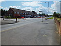
6
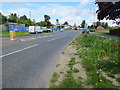
Luton: Sundon Park Road
Looking north towards Sundon; Leagrave Park is on the left.
Image: © Raymond Cubberley
Taken: 29 Jul 2012
0.23 miles