IMAGES TAKEN NEAR TO
Limbury Road, LUTON, LU3 2PH
Introduction
This page details the photographs taken nearby to Limbury Road, LU3 2PH by members of the Geograph project.
The Geograph project started in 2005 with the aim of publishing, organising and preserving representative images for every square kilometre of Great Britain, Ireland and the Isle of Man.

There are currently over 7.5m images from over14,400 individuals and you can help contribute to the project by visiting https://www.geograph.org.uk
Image Map
Images are licensed for reuse under creativecommons.org/licenses/by-sa/2.0
Notes
- Clicking on the map will re-center to the selected point.
- The higher the marker number, the further away the image location is from the centre of the postcode.
Image Listing (10 Images Found)
Images are licensed for reuse under creativecommons.org/licenses/by-sa/2.0
Image
Details
Distance


4
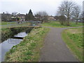
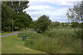
River Lea
River Lea in Limbury Meads park
Image: © Shaun Ferguson
Taken: 23 Mar 2010
0.19 miles
5
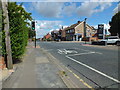
Luton:Marsh Road traffic lights
Roman Road on the left and Icknield Road on the right.
Image: © Raymond Cubberley
Taken: 29 Jul 2012
0.20 miles

7
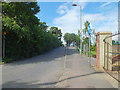
Luton: Roman Road Railway Bridge.
Owing to the volume of traffic in this area this road was made one-way many years ago.
Image: © Raymond Cubberley
Taken: 29 Jul 2012
0.23 miles
8
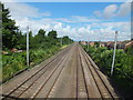
Luton to Leagrave railway line
In the far distance you just might see Leagrave Station.
Image: © Raymond Cubberley
Taken: 29 Jul 2012
0.24 miles
9

Luton to Leagrave railway line
Looking in the direction of Leagrave station from the Roman Road bridge.
Image: © Nigel Cox
Taken: 23 Jan 2007
0.24 miles
10
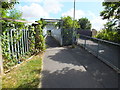
Luton: Roman Road Railway Bridge
The pedestrian side of the bridge, with the road on the left.
Image: © Raymond Cubberley
Taken: 29 Jul 2012
0.24 miles