IMAGES TAKEN NEAR TO
Derwent Avenue, LUTON, LU3 2DX
Introduction
This page details the photographs taken nearby to Derwent Avenue, LU3 2DX by members of the Geograph project.
The Geograph project started in 2005 with the aim of publishing, organising and preserving representative images for every square kilometre of Great Britain, Ireland and the Isle of Man.

There are currently over 7.5m images from over14,400 individuals and you can help contribute to the project by visiting https://www.geograph.org.uk
Image Map
Images are licensed for reuse under creativecommons.org/licenses/by-sa/2.0
Notes
- Clicking on the map will re-center to the selected point.
- The higher the marker number, the further away the image location is from the centre of the postcode.
Image Listing (15 Images Found)
Images are licensed for reuse under creativecommons.org/licenses/by-sa/2.0
Image
Details
Distance
1
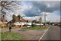
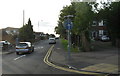
Laburnum Grove at the junction of Gooseberry Hill
Image: © David Howard
Taken: 3 Apr 2019
0.11 miles
2
Laburnum Grove at the junction of Gooseberry Hill
Image: © David Howard
Taken: 3 Apr 2019
0.11 miles
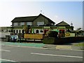
3
The Jolly Milliner
Same Public house new name in a previous life this was THE BOATER.
At the Junction of Icknield Way and Laburnum Grove.
Image: © Raymond Cubberley
Taken: 21 Jul 2012
0.12 miles
5
Grasmere Road, Luton
Off the A6 [Barton Road] at Warden Hill.
Image: © M J Richardson
Taken: 20 Sep 2017
0.16 miles
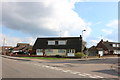
6
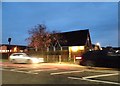
St John's church on Barton Road, Luton
Image: © David Howard
Taken: 12 Mar 2017
0.20 miles

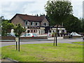
8
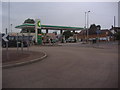
M&S service station on Barton Road roundabout
Image: © David Howard
Taken: 17 Aug 2011
0.20 miles
9

The Beefeater on Barton Road, Warden Hill
Image: © David Howard
Taken: 11 Jun 2017
0.20 miles
