IMAGES TAKEN NEAR TO
Birdsfoot Lane, LUTON, LU3 2DL
Introduction
This page details the photographs taken nearby to Birdsfoot Lane, LU3 2DL by members of the Geograph project.
The Geograph project started in 2005 with the aim of publishing, organising and preserving representative images for every square kilometre of Great Britain, Ireland and the Isle of Man.

There are currently over 7.5m images from over14,400 individuals and you can help contribute to the project by visiting https://www.geograph.org.uk
Image Map
Images are licensed for reuse under creativecommons.org/licenses/by-sa/2.0
Notes
- Clicking on the map will re-center to the selected point.
- The higher the marker number, the further away the image location is from the centre of the postcode.
Image Listing (7 Images Found)
Images are licensed for reuse under creativecommons.org/licenses/by-sa/2.0
Image
Details
Distance
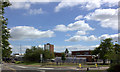
1

Cycle way between Bancroft Road and Runfold Avenue
Image: © Robert Eva
Taken: 16 Jun 2017
0.17 miles
3
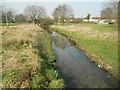
River Lee in Limbury
This is a repeat of Image taken about 9 years earlier, showing the River Lee, viewed looking upstream from near the Bancroft Road bridge, as it crosses Limbury Mead.
Image: © Nigel Cox
Taken: 12 Mar 2016
0.19 miles
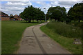
5
Junction of Riddy Lane and Birdsfoot Lane
Image: © Robert Eva
Taken: 16 Jun 2017
0.20 miles
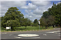
6
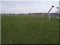
Icknield Way
Icknield Way on Icknield playing fields
Image: © Shaun Ferguson
Taken: 23 Mar 2010
0.23 miles
7
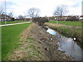
River Lee in Limbury
Looking upstream from near the Bancroft Road bridge.
Image: © Nigel Cox
Taken: 23 Jan 2007
0.24 miles